
Make a donation
Gear up for your next adventure:
As an Amazon Associate, this site earns from qualifying purchases at no extra cost to you.
Burg-Reuland topographic map
Click on the map to display elevation.
Make a donation
Gear up for your next adventure:
As an Amazon Associate, this site earns from qualifying purchases at no extra cost to you.
About this map
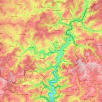
Name: Burg-Reuland topographic map, elevation, terrain.
Location: Burg-Reuland, Verviers, Luik, Wallonië, België (50.12949 6.00869 50.26460 6.19250)
Average elevation: 1,545 ft
Minimum elevation: 1,047 ft
Maximum elevation: 1,880 ft
Make a donation
Gear up for your next adventure:
As an Amazon Associate, this site earns from qualifying purchases at no extra cost to you.
Other topographic maps
Click on a map to view its topography, its elevation and its terrain.
Waimes
Weismes ligt ten oosten van Malmedy. Het noordoosten van het gemeentelijk grondgebied grenst aan Duitsland en bevat een belangrijk deel van de Hoge Venen. Het is de hoogstgelegen gemeente van België met heuveltoppen die hoogtes van meer dan zeshonderd meter bereiken, onder andere het Signaal van Botrange (694…
Average elevation: 1,745 ft
Make a donation
Gear up for your next adventure:
As an Amazon Associate, this site earns from qualifying purchases at no extra cost to you.
Baraque Michel
België > Luik > Verviers > Jalhay
De Baraque Michel (Duits : Michelshütte) is de naam van een herberg en de omliggende hoogveenvlakte in de Belgische Ardennen. De plaats ligt in een langlaufskigebied op een hoogte van 678 meter boven TAW (en 675 meter boven NN of NAP). Voor de Eerste Wereldoorlog was het een grenspunt met Pruisen en de…
Average elevation: 2,139 ft
Make a donation
Gear up for your next adventure:
As an Amazon Associate, this site earns from qualifying purchases at no extra cost to you.
Make a donation
Gear up for your next adventure:
As an Amazon Associate, this site earns from qualifying purchases at no extra cost to you.
Make a donation
Gear up for your next adventure:
As an Amazon Associate, this site earns from qualifying purchases at no extra cost to you.
Make a donation
Gear up for your next adventure:
As an Amazon Associate, this site earns from qualifying purchases at no extra cost to you.
Make a donation
Gear up for your next adventure:
As an Amazon Associate, this site earns from qualifying purchases at no extra cost to you.
Signaal van Botrange
België > Luik > Verviers > Robertville
Het Signaal van Botrange (Frans: Signal de Botrange) in de Hoge Venen is met 694 meter boven TAW (of 692 meter boven NN of NAP) het hoogste punt van België. De topografische prominentie bedraagt ongeveer 120 meter. De dominantie bedraagt 32,47 kilometer. De dichtstbijzijnde hogere top is de Schwarzer Mann in…
Average elevation: 2,162 ft
Make a donation
Gear up for your next adventure:
As an Amazon Associate, this site earns from qualifying purchases at no extra cost to you.
Make a donation
Gear up for your next adventure:
As an Amazon Associate, this site earns from qualifying purchases at no extra cost to you.
Hoëgne
België > Luik > Verviers > Jalhay
De Hoëgne ontspringt op de hoogte van Mont Rigi in Sourbrodt, een deelgemeente van Weismes. Het riviertje draagt er de naam Rû de Polleur en neemt na een vijftal kilometer de Rû de Herbofaye op, die ontspringt in de buurt van de Baraque Michel.
Average elevation: 1,460 ft
Make a donation
Gear up for your next adventure:
As an Amazon Associate, this site earns from qualifying purchases at no extra cost to you.
Raeren
België > Luik > Verviers > Raeren
Raeren ligt aan de rand van het Hertogenwald, op een hoogte van ongeveer 300 meter. In het noorden liggen enkele kleinere boscomplexen. De Iterbach stroomt door Raeren in noordoostelijke richting. In het zuiden van Raeren stroomt de Vesder. Op het grondgebied van de deelgemeente Eynatten ontspringt de Geul.
Average elevation: 1,024 ft
Make a donation
Gear up for your next adventure:
As an Amazon Associate, this site earns from qualifying purchases at no extra cost to you.
Aubel
België > Luik > Verviers > Aubel
Het dorp Aubel ligt ingeklemd tussen de vallei van de Bel in het noorden, en die van de Berwijn in het zuiden. Bij Godsdal komen deze riviertjes bij elkaar. De bron van de Bel ligt iets ten noorden van de kom van Aubel, die op een hoogte van ongeveer 200 meter is gelegen. De gemeente maakt deel uit van het…
Average elevation: 761 ft
Make a donation
Gear up for your next adventure:
As an Amazon Associate, this site earns from qualifying purchases at no extra cost to you.
Make a donation
Gear up for your next adventure:
As an Amazon Associate, this site earns from qualifying purchases at no extra cost to you.
Make a donation
Gear up for your next adventure:
As an Amazon Associate, this site earns from qualifying purchases at no extra cost to you.
Make a donation
Gear up for your next adventure:
As an Amazon Associate, this site earns from qualifying purchases at no extra cost to you.
Make a donation
Gear up for your next adventure:
As an Amazon Associate, this site earns from qualifying purchases at no extra cost to you.
Make a donation
Gear up for your next adventure:
As an Amazon Associate, this site earns from qualifying purchases at no extra cost to you.
Make a donation
Gear up for your next adventure:
As an Amazon Associate, this site earns from qualifying purchases at no extra cost to you.
Make a donation
Gear up for your next adventure:
As an Amazon Associate, this site earns from qualifying purchases at no extra cost to you.
Membach
Membach ligt nabij het dal van de Vesder, op een hoogte van ongeveer 270 meter. Ten zuiden van Membach, aan de overzijde van de Vesder, begint het Hertogenwald. Op het grondgebied van de deelgemeente bevindt zich het Artboretum van Mefferscheid.
Average elevation: 906 ft
Make a donation
Gear up for your next adventure:
As an Amazon Associate, this site earns from qualifying purchases at no extra cost to you.
Hoëgne
België > Luik > Verviers > Theux > Polleur > Nardaie de Polleur
De Hoëgne ontspringt op de hoogte van Mont Rigi in Sourbrodt, een deelgemeente van Weismes. Het riviertje draagt er de naam Rû de Polleur en neemt na een vijftal kilometer de Rû de Herbofaye op, die ontspringt in de buurt van de Baraque Michel.
Average elevation: 971 ft
Make a donation
Gear up for your next adventure:
As an Amazon Associate, this site earns from qualifying purchases at no extra cost to you.
Vaalserberg
België > Luik > Verviers > Kelmis
De Vaalserberg is een heuvel bij het Nederlandse dorp Vaals, met een hoogte van 322,4 meter boven NAP. Vlak bij de top van de heuvel ligt het Drielandenpunt, waar Nederland, België en Duitsland aan elkaar grenzen. De top van de Vaalserberg is het hoogste punt van Europees Nederland. Vlakbij staan twee…
Average elevation: 909 ft
Make a donation
Gear up for your next adventure:
As an Amazon Associate, this site earns from qualifying purchases at no extra cost to you.
Make a donation
Gear up for your next adventure:
As an Amazon Associate, this site earns from qualifying purchases at no extra cost to you.
Make a donation
Gear up for your next adventure:
As an Amazon Associate, this site earns from qualifying purchases at no extra cost to you.
Make a donation
Gear up for your next adventure:
As an Amazon Associate, this site earns from qualifying purchases at no extra cost to you.
Make a donation
Gear up for your next adventure:
As an Amazon Associate, this site earns from qualifying purchases at no extra cost to you.