Geolocate

Priest Lake topographic map

Interactive map

Click on the map to display elevation.

About this map

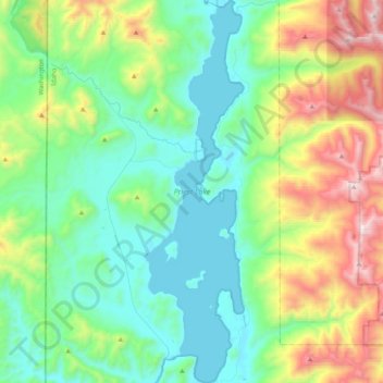
Name: Priest Lake topographic map, elevation, terrain.

Location: Priest Lake, Bonner County, Idaho, United States (48.47392 -116.92940 48.74521 -116.82205)

Average elevation: 3,684 ft

Minimum elevation: 2,421 ft

Maximum elevation: 7,287 ft

Bonner County trails, hiking, mountain biking, running and outdoor activities

Other topographic maps

Click on a map to view its topography, its elevation and its terrain.

Oden Bay

United States > Idaho > Bonner County

Average elevation: 2,054 ft

Sagle

United States > Idaho > Bonner County

Average elevation: 2,270 ft

Pend Oreille River

United States > Idaho > Bonner County > Oldtown

Average elevation: 2,156 ft

Careywood

United States > Idaho > Bonner County

Average elevation: 2,428 ft

Cedar Creek

United States > Idaho > Bonner County

Average elevation: 2,454 ft

Blanchard

United States > Idaho > Bonner County

Average elevation: 2,356 ft

Sandpoint

United States > Idaho > Bonner County > Sandpoint

Average elevation: 2,254 ft