
Burleson topographic map
Interactive map
Click on the map to display elevation.
About this map
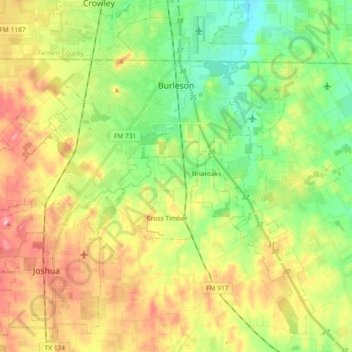
Name: Burleson topographic map, elevation, terrain.
Location: Burleson, Johnson County, Texas, United States (32.43272 -97.43155 32.57192 -97.24890)
Average elevation: 801 ft
Minimum elevation: 633 ft
Maximum elevation: 1,024 ft
As of 2010, Burleson had a total area of 26.07 square miles (67.52 km2), of which 26.01 square miles (67.36 km2) were land and 0.07 square miles (0.17 km2), or 0.25%, were water. Village Creek, a tributary of the Trinity River, flows to the northeast through the city. Most of Burleson lies between 700 and 800 feet (210 and 240 m) in elevation.
Other topographic maps
Click on a map to view its topography, its elevation and its terrain.
Alvarado
United States > Texas > Johnson County
Alvarado, Johnson County, Texas, 76007, United States
Average elevation: 735 ft
Joshua
United States > Texas > Johnson County
Joshua, Johnson County, Texas, United States
Average elevation: 883 ft
Rio Vista
United States > Texas > Johnson County
Rio Vista, Johnson County, Texas, United States
Average elevation: 719 ft
Egan
United States > Texas > Johnson County
Egan, Johnson County, Texas, United States
Average elevation: 837 ft
Cuba
United States > Texas > Johnson County
Cuba, Johnson County, Texas, United States
Average elevation: 804 ft
Cleburne
United States > Texas > Johnson County
Cleburne, Johnson County, Texas, United States
Average elevation: 833 ft
Grandview
United States > Texas > Johnson County
Grandview, Johnson County, Texas, United States
Average elevation: 676 ft
Venus
United States > Texas > Johnson County
Venus, Johnson County, Texas, 76084, United States
Average elevation: 656 ft