
South Orange topographic map
Interactive map
Click on the map to display elevation.
South Orange
The western part of the town sits on the eastern slope of South Mountain (elevation <660 feet (201 m)), leveling into a small valley near the central business district. At the top of the slope, the western edge of the town runs along the eastern border of South Mountain Reservation. South Orange contains the historic Montrose district, Newstead, Tuxedo Park, and Wyoming sections.[55] Seton Hall University is located in the southeast quadrant of the township.[56]
About this map
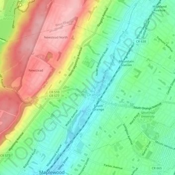
Name: South Orange topographic map, elevation, terrain.
Location: South Orange, Essex County, New Jersey, 07079, United States (40.73562 -74.28318 40.76230 -74.23470)
Average elevation: 308 ft
Minimum elevation: 115 ft
Maximum elevation: 604 ft
Essex County trails, hiking, mountain biking, running and outdoor activities
Other topographic maps
Click on a map to view its topography, its elevation and its terrain.
Eagle Rock Reservation
United States > New Jersey > Essex County > West Orange
Average elevation: 472 ft
Mills Reservation
United States > New Jersey > Essex County > Montclair > Montclair Heights
Average elevation: 397 ft
Cedar Grove
United States > New Jersey > Essex County > Cedar Grove
The township is located between the First and Second Watchung Mountains. The center of the township is in a valley that is about 280 feet (85 m) above sea level; however, many sections of Cedar Grove are well above 400 feet (120 m), including the Park Ridge Estates, the abandoned Essex County Hospital Center,…
Average elevation: 354 ft