
Make a donation
Gear up for your next adventure:
As an Amazon Associate, this site earns from qualifying purchases at no extra cost to you.
Traverse City topographic map
Click on the map to display elevation.
Make a donation
Gear up for your next adventure:
As an Amazon Associate, this site earns from qualifying purchases at no extra cost to you.
Traverse City
The locale and topography is conducive for road bicycling, aided by the TART trail system. A map with routes, different trips, advice and local knowledge is available. Lake Michigan presents a location for sailing, fishing, and kayaking.
Make a donation
Gear up for your next adventure:
As an Amazon Associate, this site earns from qualifying purchases at no extra cost to you.
About this map
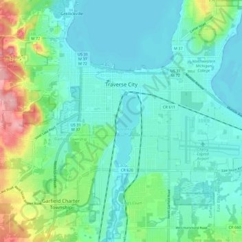
Name: Traverse City topographic map, elevation, terrain.
Average elevation: 669 ft
Minimum elevation: 571 ft
Maximum elevation: 1,007 ft
Grand Traverse County trails, hiking, mountain biking, running and outdoor activities
Make a donation
Gear up for your next adventure:
As an Amazon Associate, this site earns from qualifying purchases at no extra cost to you.
Other topographic maps
Click on a map to view its topography, its elevation and its terrain.
Lookout Point
United States > Michigan > Grand Traverse County > Peninsula Township
Average elevation: 617 ft
Old Mission
United States > Michigan > Grand Traverse County
Old Mission is located just east of M-37 near the tip of Old Mission Peninsula about 16 miles (25.75 km) north of Traverse City. The community was built along Old Mission Harbor, which is a small safe haven along the East Arm of Grand Traverse Bay. The community sits at an elevation of 587 feet (179 m) above…
Average elevation: 623 ft
Make a donation
Gear up for your next adventure:
As an Amazon Associate, this site earns from qualifying purchases at no extra cost to you.
Diamond Park
United States > Michigan > Grand Traverse County > Green Lake Township
Average elevation: 837 ft