
Make a donation
Gear up for your next adventure:
As an Amazon Associate, this site earns from qualifying purchases at no extra cost to you.
Atlanta topographic map
Click on the map to display elevation.
Make a donation
Gear up for your next adventure:
As an Amazon Associate, this site earns from qualifying purchases at no extra cost to you.
Atlanta
Atlanta features a varied topography characterized by its rolling hills and elevated terrain. The city sits at an average elevation of approximately 1,050 feet (320 meters) above sea level, with elevations ranging from about 725 feet (221 meters) to 1,175 feet (358 meters) in the surrounding areas. This elevation provides a natural landscape that includes numerous small hills and valleys, contributing to the scenic beauty of the region. The area is also intersected by waterways like the Chattahoochee River, which adds to the diversity of its topographic features. The terrain's undulations not only shape the urban landscape but also offer various recreational opportunities in nearby parks and green spaces, making Atlanta a vibrant city with a rich outdoor environment.
Make a donation
Gear up for your next adventure:
As an Amazon Associate, this site earns from qualifying purchases at no extra cost to you.
About this map
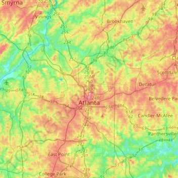
Name: Atlanta topographic map, elevation, terrain.
Location: Atlanta, Fulton County, Georgia, United States (33.64792 -84.55085 33.88682 -84.28956)
Average elevation: 932 ft
Minimum elevation: 741 ft
Maximum elevation: 1,171 ft
Fulton County trails, hiking, mountain biking, running and outdoor activities
Make a donation
Gear up for your next adventure:
As an Amazon Associate, this site earns from qualifying purchases at no extra cost to you.
Other topographic maps
Click on a map to view its topography, its elevation and its terrain.
Atlanta
United States > Georgia > Fulton County
Atlanta (/ætˈlæntə/ at-LAN-tə) is the capital and most populous city of the U.S. state of Georgia. It is the seat of Fulton County, the most populous county in Georgia. With a population of 498,715 living within the city limits, it is the eighth most populous city in the Southeast and 38th most populous…
Average elevation: 935 ft
Morning Creek Estates
United States > Georgia > Fulton County > South Fulton
Average elevation: 958 ft
Make a donation
Gear up for your next adventure:
As an Amazon Associate, this site earns from qualifying purchases at no extra cost to you.
Make a donation
Gear up for your next adventure:
As an Amazon Associate, this site earns from qualifying purchases at no extra cost to you.
Make a donation
Gear up for your next adventure:
As an Amazon Associate, this site earns from qualifying purchases at no extra cost to you.
Johns Creek
United States > Georgia > Fulton County > Johns Creek
Johns Creek is located in northeastern Fulton County and is centered at 34°1′44″N 84°11′55″W / 34.02889°N 84.19861°W / 34.02889; -84.19861 (34.0289259, -84.1985790). The elevation ranges from 880 feet (270 m) above sea level along the Chattahoochee River to 1,180 feet (360 m) in the Ocee…
Average elevation: 1,030 ft
Make a donation
Gear up for your next adventure:
As an Amazon Associate, this site earns from qualifying purchases at no extra cost to you.
Capital City Country Club Lake Dam
United States > Georgia > Fulton County > Atlanta
Average elevation: 965 ft
Johns Creek
United States > Georgia > Fulton County > Johns Creek > Johns Creek
Average elevation: 1,001 ft