
Grosse Pointe topographic map
Interactive map
Click on the map to display elevation.
About this map
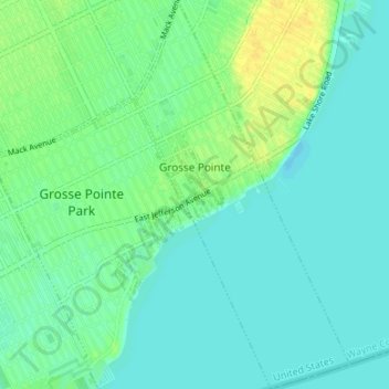
Name: Grosse Pointe topographic map, elevation, terrain.
Location: Grosse Pointe, Wayne County, Michigan, United States (42.35753 -82.92240 42.40727 -82.88494)
Average elevation: 584 ft
Minimum elevation: 561 ft
Maximum elevation: 630 ft
Wayne County trails, hiking, mountain biking, running and outdoor activities
Other topographic maps
Click on a map to view its topography, its elevation and its terrain.
Edgewater Heights
United States > Michigan > Wayne County > Van Buren Charter Township
Average elevation: 682 ft
Detroit
United States > Michigan > Wayne County
The city slopes gently from the northwest to southeast on a till plain composed largely of glacial and lake clay. The most notable topographical feature in the city is the Detroit Moraine, a broad clay ridge on which the older portions of Detroit and Windsor are located, rising approximately 62 feet (19 m)…
Average elevation: 610 ft
Belleville North
United States > Michigan > Wayne County > Van Buren Charter Township
Average elevation: 682 ft
Redford
United States > Michigan > Wayne County > Redford Township > Redford
Average elevation: 633 ft