
Kahului topographic map
Interactive map
Click on the map to display elevation.
About this map
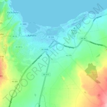
Name: Kahului topographic map, elevation, terrain.
Location: Kahului, Maui County, Hawaii, United States (20.84547 -156.50042 20.90215 -156.40225)
Average elevation: 121 ft
Minimum elevation: -10 ft
Maximum elevation: 499 ft
Maui County trails, hiking, mountain biking, running and outdoor activities
Other topographic maps
Click on a map to view its topography, its elevation and its terrain.
Kula
United States > Hawaii > Maui County
Kula is a district and census-designated place (CDP) of Maui, Hawaii, that stretches across the "up-country", the western-facing slopes of Haleakalā, from Makawao to Kanaio. Most of the residential areas lie between about 500 to 1,100 m (1,600 to 3,600 ft) in elevation. The district has traditionally been…
Average elevation: 2,428 ft