
Winthrop topographic map
Interactive map
Click on the map to display elevation.
About this map
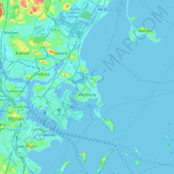
Name: Winthrop topographic map, elevation, terrain.
Average elevation: 16 ft
Minimum elevation: -10 ft
Maximum elevation: 233 ft
Suffolk County trails, hiking, mountain biking, running and outdoor activities
Other topographic maps
Click on a map to view its topography, its elevation and its terrain.
Boston National Historical Park
United States > Massachusetts > Suffolk County > Boston
Average elevation: 30 ft
Charles River
United States > Massachusetts > Suffolk County > Boston
As native populations were driven out by European settlers, the Charles River became an early center for hydropower and manufacturing in North America. Although in portions of its length, the Charles drops slowly in elevation and has relatively little current, early settlers in Dedham, Massachusetts, found a…
Average elevation: 33 ft
Smith Family Waterfront
United States > Massachusetts > Suffolk County > Boston
Average elevation: 26 ft
Chelsea
United States > Massachusetts > Suffolk County > Chelsea
The topography of Chelsea consists primarily of coastal lowlands, punctuated by four drumlins formed during the last Ice Age. These drumlins are located in the southwest (Admirals Hill), southeast (Mount Bellingham), northeast (Powderhorn Hill) and northwest (Mount Washington). A smaller drumlin (Mill Hill) is…
Average elevation: 26 ft
Revere Beach
United States > Massachusetts > Suffolk County > Revere > Crescent Beach
Average elevation: 10 ft
Little Brewster Island
United States > Massachusetts > Suffolk County > Boston
Average elevation: 0 ft