
Make a donation
Gear up for your next adventure:
As an Amazon Associate, this site earns from qualifying purchases at no extra cost to you.
Redmond topographic map
Click on the map to display elevation.
Make a donation
Gear up for your next adventure:
As an Amazon Associate, this site earns from qualifying purchases at no extra cost to you.
Redmond
Redmond features a diverse topography characterized by its gently rolling hills and lush landscapes. The city lies at an average elevation of approximately 250 feet (76 meters) above sea level, with elevations varying between 15 feet (5 meters) to about 500 feet (152 meters) across the region. This varied terrain is interspersed with wooded areas, wetlands, and parks, contributing to its scenic beauty. The topography is influenced by the nearby Cascade Range to the east, which includes taller mountainous regions that provide a stunning backdrop. The overall landscape supports a rich ecosystem, making Redmond not only visually appealing but also a hub for outdoor activities such as hiking and cycling.
Make a donation
Gear up for your next adventure:
As an Amazon Associate, this site earns from qualifying purchases at no extra cost to you.
About this map
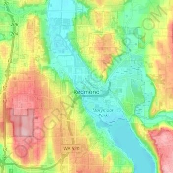
Name: Redmond topographic map, elevation, terrain.
Location: Redmond, King County, Washington, 98052, United States (47.62714 -122.16498 47.71702 -122.03462)
Average elevation: 236 ft
Minimum elevation: 3 ft
Maximum elevation: 604 ft
King County trails, hiking, mountain biking, running and outdoor activities
Make a donation
Gear up for your next adventure:
As an Amazon Associate, this site earns from qualifying purchases at no extra cost to you.
Other topographic maps
Click on a map to view its topography, its elevation and its terrain.
Stampede Pass
United States > Washington > King County
Stampede Pass (elevation 3,672 feet (1,119 m)) is a mountain pass in the northwest United States, through the Cascade Range in Washington. Southeast of Seattle and east of Tacoma, its importance to transportation lies almost entirely with railroading, as no paved roads cross it. It is approximately twelve…
Average elevation: 3,724 ft
Make a donation
Gear up for your next adventure:
As an Amazon Associate, this site earns from qualifying purchases at no extra cost to you.
Mount Index
United States > Washington > King County
Mount Index is a peak in the central part of the Cascade Range of Washington state. It lies just south of the Skykomish River and U.S. Route 2, at the western edge of the Cascades. Despite its low elevation relative to peaks higher in the Cascades, it is a famous and dramatic landmark due to its topographic…
Average elevation: 3,865 ft
Hot Springs
United States > Washington > King County
Hot Springs is located east of Enumclaw and just west of Lester, along the Green River and BNSF Railway line. Its elevation is 1512 feet (460m) above sea level.
Average elevation: 1,929 ft
Make a donation
Gear up for your next adventure:
As an Amazon Associate, this site earns from qualifying purchases at no extra cost to you.
West Hylebos Wetlands Park
United States > Washington > King County > Federal Way
Average elevation: 276 ft
Make a donation
Gear up for your next adventure:
As an Amazon Associate, this site earns from qualifying purchases at no extra cost to you.
Make a donation
Gear up for your next adventure:
As an Amazon Associate, this site earns from qualifying purchases at no extra cost to you.
Make a donation
Gear up for your next adventure:
As an Amazon Associate, this site earns from qualifying purchases at no extra cost to you.
Make a donation
Gear up for your next adventure:
As an Amazon Associate, this site earns from qualifying purchases at no extra cost to you.
Make a donation
Gear up for your next adventure:
As an Amazon Associate, this site earns from qualifying purchases at no extra cost to you.
Make a donation
Gear up for your next adventure:
As an Amazon Associate, this site earns from qualifying purchases at no extra cost to you.
Stevens Pass
United States > Washington > King County
Stevens Pass (elevation 4,061 ft (1,238 m)) is a mountain pass through the Cascade Mountains located at the border of King County and Chelan County in Washington, United States. U.S. Route 2 travels over the pass, reaching a maximum elevation of 4,061 feet (1,238 m). The Pacific Crest Trail crosses the highway…
Average elevation: 4,551 ft
Lester
United States > Washington > King County
Lester is located, east of Enumclaw, Washington along the Green River and BNSF Railway line. Its elevation is 1,634 feet (498 m) above sea level.
Average elevation: 2,264 ft
Make a donation
Gear up for your next adventure:
As an Amazon Associate, this site earns from qualifying purchases at no extra cost to you.
Make a donation
Gear up for your next adventure:
As an Amazon Associate, this site earns from qualifying purchases at no extra cost to you.
Mount Si
United States > Washington > King County
The peak can be accessed by two trails. The Old Mount Si trail is accessed by the Little Si parking lot and the Boulder Garden Loop. It is 0.6 miles (0.97 km) shorter, 270 feet (82 m) steeper in elevation gain, and less crowded than the main trail. The Mount Si trail is accessed by the Mount Si parking lot.
Average elevation: 2,582 ft
Make a donation
Gear up for your next adventure:
As an Amazon Associate, this site earns from qualifying purchases at no extra cost to you.
Hot Springs
United States > Washington > King County
Hot Springs is located east of Enumclaw and just west of Lester, along the Green River and BNSF Railway line. Its elevation is 1512 feet (460m) above sea level.
Average elevation: 1,929 ft
Mount Si
United States > Washington > King County
The peak can be accessed by two trails. The Old Mount Si trail is accessed by the Little Si parking lot and the Boulder Garden Loop. It is 0.6 miles (0.97 km) shorter, 270 feet (82 m) steeper in elevation gain, and less crowded than the main trail. The Mount Si trail is accessed by the Mount Si parking lot.
Average elevation: 2,602 ft
Make a donation
Gear up for your next adventure:
As an Amazon Associate, this site earns from qualifying purchases at no extra cost to you.
Make a donation
Gear up for your next adventure:
As an Amazon Associate, this site earns from qualifying purchases at no extra cost to you.
Asian Small-Clawed Otters
United States > Washington > King County > Seattle
Average elevation: 203 ft
Make a donation
Gear up for your next adventure:
As an Amazon Associate, this site earns from qualifying purchases at no extra cost to you.
Make a donation
Gear up for your next adventure:
As an Amazon Associate, this site earns from qualifying purchases at no extra cost to you.
Mount Si
United States > Washington > King County
The peak can be accessed by two trails. The Old Mount Si trail is accessed by the Little Si parking lot and the Boulder Garden Loop. It is 0.6 miles (0.97 km) shorter, 270 feet (82 m) steeper in elevation gain, and less crowded than the main trail. The Mount Si trail is accessed by the Mount Si parking lot.
Average elevation: 2,582 ft
Mercer Island
United States > Washington > King County > Mercer Island
Mercer Island City Hall is located at 47°34′39″N 122°12′43.2″W / 47.57750°N 122.212000°W / 47.57750; -122.212000 (47.5775, -122.212). The peak elevation in the city is about 338 feet (103 m), near the center of the island.
Average elevation: 128 ft
Make a donation
Gear up for your next adventure:
As an Amazon Associate, this site earns from qualifying purchases at no extra cost to you.
Make a donation
Gear up for your next adventure:
As an Amazon Associate, this site earns from qualifying purchases at no extra cost to you.
Preston
United States > Washington > King County
Preston is a historic mill town on the northeast edge of the large Tiger Mountain State Forest, along Interstate 90. Preston, elevation 430 ft (130 m), is located within commuting distance of Seattle and Bellevue.
Average elevation: 886 ft
Make a donation
Gear up for your next adventure:
As an Amazon Associate, this site earns from qualifying purchases at no extra cost to you.
Make a donation
Gear up for your next adventure:
As an Amazon Associate, this site earns from qualifying purchases at no extra cost to you.
Make a donation
Gear up for your next adventure:
As an Amazon Associate, this site earns from qualifying purchases at no extra cost to you.
Arbor Heights
United States > Washington > King County > Seattle > Arbor Heights
Average elevation: 197 ft
Make a donation
Gear up for your next adventure:
As an Amazon Associate, this site earns from qualifying purchases at no extra cost to you.
Lake Forest Park
United States > Washington > King County > Lake Forest Park > Lake Forest Park
Average elevation: 279 ft
Make a donation
Gear up for your next adventure:
As an Amazon Associate, this site earns from qualifying purchases at no extra cost to you.
Maple Valley
United States > Washington > King County > Maple Valley > Maple Valley
Average elevation: 545 ft
Make a donation
Gear up for your next adventure:
As an Amazon Associate, this site earns from qualifying purchases at no extra cost to you.
Make a donation
Gear up for your next adventure:
As an Amazon Associate, this site earns from qualifying purchases at no extra cost to you.