
London topographic map
Interactive map
Click on the map to display elevation.
About this map
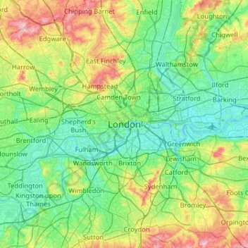
Name: London topographic map, elevation, terrain.
Location: London, Greater London, England, SW1A 2DX, United Kingdom (51.34732 -0.28765 51.66732 0.03235)
Average elevation: 138 ft
Minimum elevation: -10 ft
Maximum elevation: 535 ft
Other topographic maps
Click on a map to view its topography, its elevation and its terrain.
Gorilla Circus Regents Park Flying Trapeze School
United Kingdom > England > London > Camden Town
Average elevation: 135 ft
London Borough of Bromley
United Kingdom > England > London
Westerham Heights, the highest point in London and Kent at an altitude of 804 feet (245 m), is on the southern boundary. The Prime Meridian passes through Bromley.
Average elevation: 341 ft