
Make a donation
Gear up for your next adventure:
As an Amazon Associate, this site earns from qualifying purchases at no extra cost to you.
Blacksburg topographic map
Click on the map to display elevation.
Make a donation
Gear up for your next adventure:
As an Amazon Associate, this site earns from qualifying purchases at no extra cost to you.
Blacksburg
Blacksburg exhibits a varied topography characterized by its rolling hills and elevation changes. The town is situated at an average elevation of approximately 2,040 feet (621 meters) above sea level, with elevations ranging from about 1,440 feet (440 meters) to peaks reaching approximately 2,800 feet (860 meters). The landscape is largely influenced by the Appalachian Mountains to the west, contributing to a picturesque setting of steep ridges and valleys. This mountainous terrain is interspersed with waterways, including Stroubles Creek, which meanders through the region, further enhancing the natural beauty. The local geography supports a variety of outdoor recreational opportunities, appealing to both residents and visitors who enjoy hiking, biking, and exploring the scenic vistas.
Make a donation
Gear up for your next adventure:
As an Amazon Associate, this site earns from qualifying purchases at no extra cost to you.
About this map
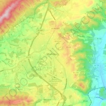
Name: Blacksburg topographic map, elevation, terrain.
Location: Blacksburg, Montgomery County, Virginia, United States (37.18389 -80.48068 37.27693 -80.37912)
Average elevation: 2,037 ft
Minimum elevation: 1,444 ft
Maximum elevation: 2,822 ft
Montgomery County trails, hiking, mountain biking, running and outdoor activities
Make a donation
Gear up for your next adventure:
As an Amazon Associate, this site earns from qualifying purchases at no extra cost to you.
Other topographic maps
Click on a map to view its topography, its elevation and its terrain.
Ramble Ridge
United States > Virginia > Montgomery County > Blacksburg > Ramble Ridge
Average elevation: 2,073 ft
Southgate
United States > Virginia > Montgomery County > Blacksburg > Southgate
Average elevation: 2,110 ft
Make a donation
Gear up for your next adventure:
As an Amazon Associate, this site earns from qualifying purchases at no extra cost to you.