
Kerrville topographic map
Interactive map
Click on the map to display elevation.
Kerrville
Kerrville is characterized by a diverse and rugged topography. Nestled along the Guadalupe River, it sits at an elevation averaging 1,600 feet above sea level, with varying terrain that includes gentle hills, steep slopes, and flat river valleys. This area features numerous limestone hills, characteristic of the Edwards Plateau, as well as smaller ridges and escarpments that create an intricate landscape. The terrain includes densely vegetated areas along the river and open fields across the rolling hills, providing distinct natural beauty and varied ecosystems. This rugged yet scenic region is marked by changes in elevation that add to its appeal for outdoor recreation, such as hiking and scenic drives, especially around the Guadalupe River and nearby creeks.
About this map
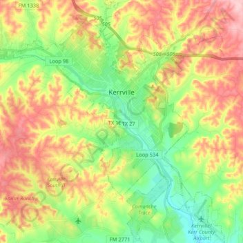
Name: Kerrville topographic map, elevation, terrain.
Location: Kerrville, Kerr County, Texas, United States (29.96182 -99.21161 30.10132 -99.07165)
Average elevation: 1,788 ft
Minimum elevation: 1,522 ft
Maximum elevation: 2,119 ft
Kerr County trails, hiking, mountain biking, running and outdoor activities
Other topographic maps
Click on a map to view its topography, its elevation and its terrain.