
Midland topographic map
Interactive map
Click on the map to display elevation.
About this map
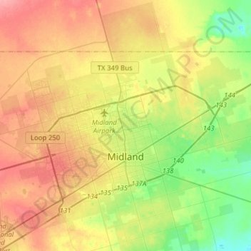
Name: Midland topographic map, elevation, terrain.
Location: Midland, Midland County, Texas, United States (31.91841 -102.26980 32.12939 -102.01767)
Average elevation: 2,805 ft
Minimum elevation: 2,687 ft
Maximum elevation: 2,930 ft
Midland County trails, hiking, mountain biking, running and outdoor activities
Other topographic maps
Click on a map to view its topography, its elevation and its terrain.
Chris Davidson Opportunity Park
United States > Texas > Midland County > Midland
Average elevation: 2,854 ft