
Make a donation
Gear up for your next adventure:
As an Amazon Associate, this site earns from qualifying purchases at no extra cost to you.
Simi Valley topographic map
Click on the map to display elevation.
Make a donation
Gear up for your next adventure:
As an Amazon Associate, this site earns from qualifying purchases at no extra cost to you.
Simi Valley
Simi Valley is a city located in the very southeast corner of Ventura County, bordering the San Fernando Valley in Los Angeles County, and is a part of the Greater Los Angeles Area. The city of Simi Valley basically consists of the eponymous valley itself. The city of Simi Valley borders the Santa Susana Mountains to the north, the Simi Hills to the east and south, and is adjacent to Thousand Oaks to the southwest and Moorpark to the west. Simi Valley is connected to the nearby San Fernando Valley by the Santa Susana Pass in the extreme east of Simi Valley. Simi Valley is located at 34°16'16" North, 118°44'22" West (34.271078, −118.739428) with an elevation of 700–1,000 ft (210–300 m) above sea level. The syncline Simi Valley is located in the western part of the region called the Transverse Ranges. The valley is surrounded by the Santa Susana Mountains to the north and Simi Hills to the east and south. While the Santa Susana Mountains separate the valley from the Los Padres National Forest in the north, the Simi Hills separate it from Conejo Valley in the south. In the extreme east is Rocky Peak, one of Santa Susana Mountains' highest peaks, which is a dividing line between Ventura County to the west and Los Angeles County to the east. On the other side of the valley, in the extreme west side of Simi Valley is Mount McCoy, which may be most known for its 12 ft. concrete cross that sits at its peak. The physiographical valley is a structural as well as a topographic depression. The Simi Valley, just as neighboring San Fernando Valley, owes its existence and shape to the faulting and folding of the rocks. It is essentially a structural valley and not wholly the work of erosion. It is drained by the Calleguas Creek and also its principal tributary, Conejo Creek. Both of these originate in the Santa Susana Mountains.
Make a donation
Gear up for your next adventure:
As an Amazon Associate, this site earns from qualifying purchases at no extra cost to you.
About this map
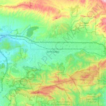
Name: Simi Valley topographic map, elevation, terrain.
Location: Simi Valley, Ventura County, California, United States (34.20842 -118.83110 34.32267 -118.63256)
Average elevation: 1,329 ft
Minimum elevation: 577 ft
Maximum elevation: 2,920 ft
Ventura County trails, hiking, mountain biking, running and outdoor activities
Make a donation
Gear up for your next adventure:
As an Amazon Associate, this site earns from qualifying purchases at no extra cost to you.
Other topographic maps
Click on a map to view its topography, its elevation and its terrain.
Mount Pinos
United States > California > Ventura County
During and immediately after heavy snow storms it may not be possible to drive to the top of Mount Pinos Road due to the lack of snow plow availability. In such cases it is common for the Kern County Roads Department to close a snow gate lower on the mountain. It is still possible to ski from the snow gate and…
Average elevation: 8,097 ft
Make a donation
Gear up for your next adventure:
As an Amazon Associate, this site earns from qualifying purchases at no extra cost to you.
Make a donation
Gear up for your next adventure:
As an Amazon Associate, this site earns from qualifying purchases at no extra cost to you.
Newbury Park
United States > California > Ventura County > Thousand Oaks > Newbury Park
Newbury Park can be described as a town, community, or section mostly within the Thousand Oaks city limits in addition to rural areas west of Thousand Oaks. Newbury Park is bordered by Lynn Road in the east and the Conejo Grade on the west. It borders the Santa Monica Mountains in the south, while Hill Canyon…
Average elevation: 860 ft
Make a donation
Gear up for your next adventure:
As an Amazon Associate, this site earns from qualifying purchases at no extra cost to you.
Jasmine Glen Estates
United States > California > Ventura County > Simi Valley
Average elevation: 1,086 ft
Lake Piru
United States > California > Ventura County
The elevation of the reservoir is 1,043 ft (318 m), and the elevation of the dam spillway is 1,055 ft (322 m). The dam is owned and operated by the United Water Conservation District based in nearby Santa Paula, California. The district is a multi-service district providing flood control, recreation services,…
Average elevation: 1,230 ft
Johnson Creek Park
United States > California > Ventura County > Oxnard > Pleasant Valley Mobile Home Park
Average elevation: 33 ft
Make a donation
Gear up for your next adventure:
As an Amazon Associate, this site earns from qualifying purchases at no extra cost to you.
Casitas Springs
United States > California > Ventura County > Ventura > Casitas Springs
Average elevation: 597 ft
Greenwich Village
United States > California > Ventura County > Thousand Oaks > Greenwich Village
Average elevation: 902 ft
Make a donation
Gear up for your next adventure:
As an Amazon Associate, this site earns from qualifying purchases at no extra cost to you.