
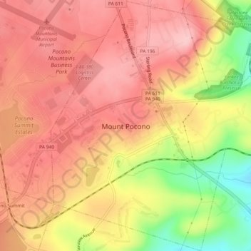
Mount Pocono topographic map
Interactive map
Click on the map to display elevation.
About this map
Name: Mount Pocono topographic map, elevation, terrain.
Average elevation: 1,762 ft
Minimum elevation: 1,414 ft
Maximum elevation: 1,939 ft
Monroe County trails, hiking, mountain biking, running and outdoor activities
Other topographic maps
Click on a map to view its topography, its elevation and its terrain.
Buck Hill Falls
United States > Pennsylvania > Monroe County > Barrett Township > Mountainhome
Average elevation: 1,247 ft
Great Wolf Lodge Water Park
United States > Pennsylvania > Monroe County > Pocono Township > Scotrun
Average elevation: 1,161 ft
Tobyhanna
United States > Pennsylvania > Monroe County > Coolbaugh Township
Average elevation: 1,936 ft
Kalahari Indoor Waterpark
United States > Pennsylvania > Monroe County > Tobyhanna Township
Average elevation: 1,814 ft
Marshalls Creek
United States > Pennsylvania > Monroe County > Smithfield Township
Average elevation: 610 ft
Gilbert
United States > Pennsylvania > Monroe County > Chestnuthill Township
Average elevation: 794 ft
Blakeslee
United States > Pennsylvania > Monroe County > Tobyhanna Township
Average elevation: 1,654 ft
Camelback Mountain
United States > Pennsylvania > Monroe County > Jackson Township
Average elevation: 1,503 ft
Kunkletown
United States > Pennsylvania > Monroe County > Eldred Township
Kunkletown is an unincorporated community in Eldred Township, Monroe County, Pennsylvania, United States. It is located at an elevation of 531 feet. It is at ZIP Code 18058.
Average elevation: 735 ft
Pocono Summit
United States > Pennsylvania > Monroe County > Tobyhanna Township
Average elevation: 1,795 ft
Pinecrest Lake
United States > Pennsylvania > Monroe County > Tobyhanna Township
Average elevation: 1,824 ft
Otter Lake
United States > Pennsylvania > Monroe County > Middle Smithfield Township
Average elevation: 1,158 ft
Shawnee on Delaware
United States > Pennsylvania > Monroe County > Smithfield Township
Average elevation: 617 ft
Camelot Forest
United States > Pennsylvania > Monroe County > Tobyhanna Township
Average elevation: 1,686 ft