
Make a donation
Gear up for your next adventure:
As an Amazon Associate, this site earns from qualifying purchases at no extra cost to you.
New Concord topographic map
Click on the map to display elevation.
Gear up for your next adventure:
As an Amazon Associate, this site earns from qualifying purchases at no extra cost to you.
About this map
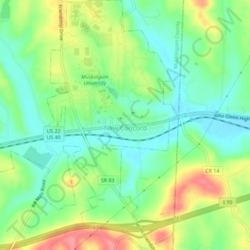
Name: New Concord topographic map, elevation, terrain.
Location: New Concord, Muskingum County, Ohio, 43762, United States (39.97807 -81.75595 40.00958 -81.72529)
Average elevation: 928 ft
Minimum elevation: 817 ft
Maximum elevation: 1,106 ft
Muskingum County trails, hiking, mountain biking, running and outdoor activities
Make a donation
Gear up for your next adventure:
As an Amazon Associate, this site earns from qualifying purchases at no extra cost to you.
Other topographic maps
Click on a map to view its topography, its elevation and its terrain.
Make a donation
Gear up for your next adventure:
As an Amazon Associate, this site earns from qualifying purchases at no extra cost to you.
Make a donation
Gear up for your next adventure:
As an Amazon Associate, this site earns from qualifying purchases at no extra cost to you.
Hopewell
United States > Ohio > Muskingum County
The community is situated on U.S. Route 40, about a half mile north of Interstate 70, and about nine miles west of Zanesville at 39°57'21" north latitude, 82°10'15" west longitude. The ZIP code is 43746; the FIPS place code is 36358; and the elevation 1100 feet above sea level.
Average elevation: 1,001 ft