
Make a donation
Gear up for your next adventure:
As an Amazon Associate, this site earns from qualifying purchases at no extra cost to you.
Jeannette topographic map
Click on the map to display elevation.
Make a donation
Gear up for your next adventure:
As an Amazon Associate, this site earns from qualifying purchases at no extra cost to you.
About this map
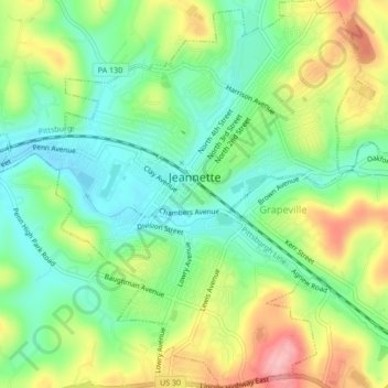
Name: Jeannette topographic map, elevation, terrain.
Average elevation: 1,138 ft
Minimum elevation: 965 ft
Maximum elevation: 1,414 ft
Westmoreland County trails, hiking, mountain biking, running and outdoor activities
Make a donation
Gear up for your next adventure:
As an Amazon Associate, this site earns from qualifying purchases at no extra cost to you.
Other topographic maps
Click on a map to view its topography, its elevation and its terrain.
Torrance
United States > Pennsylvania > Westmoreland County > Derry Township
Average elevation: 1,214 ft
Moween
United States > Pennsylvania > Westmoreland County > Loyalhanna Township
Average elevation: 1,047 ft
Alice
United States > Pennsylvania > Westmoreland County > Mount Pleasant Township
Average elevation: 1,476 ft
Alverton
United States > Pennsylvania > Westmoreland County > East Huntingdon Township
Average elevation: 1,184 ft
Make a donation
Gear up for your next adventure:
As an Amazon Associate, this site earns from qualifying purchases at no extra cost to you.
Fort Allen
United States > Pennsylvania > Westmoreland County > Hempfield Township
Average elevation: 1,138 ft
Forbes Road
United States > Pennsylvania > Westmoreland County > Salem Township
Average elevation: 1,201 ft
Whites Hill
United States > Pennsylvania > Westmoreland County > Hempfield Township
Average elevation: 1,063 ft
Make a donation
Gear up for your next adventure:
As an Amazon Associate, this site earns from qualifying purchases at no extra cost to you.
Jones Mills
United States > Pennsylvania > Westmoreland County > Donegal Township
Average elevation: 1,716 ft
Oak Grove
United States > Pennsylvania > Westmoreland County > Ligonier Township
Average elevation: 1,358 ft
Basforth Acres
United States > Pennsylvania > Westmoreland County > Hempfield Township
Average elevation: 1,243 ft
Squirrel Hill
United States > Pennsylvania > Westmoreland County > Saint Clair Township
Average elevation: 1,161 ft
Make a donation
Gear up for your next adventure:
As an Amazon Associate, this site earns from qualifying purchases at no extra cost to you.
Roaring Run Natural Area
United States > Pennsylvania > Westmoreland County > Donegal Township
Average elevation: 2,490 ft
Hopewell
United States > Pennsylvania > Westmoreland County > Donegal Township > Hopewell
Average elevation: 1,778 ft
Stanton Heights
United States > Pennsylvania > Westmoreland County > New Stanton > Stanton Heights
Average elevation: 1,073 ft
Paintersville
United States > Pennsylvania > Westmoreland County > New Stanton > Paintersville
Average elevation: 1,063 ft
Make a donation
Gear up for your next adventure:
As an Amazon Associate, this site earns from qualifying purchases at no extra cost to you.
Midway
United States > Pennsylvania > Westmoreland County > Hempfield Township > Midway
Average elevation: 1,083 ft
Fellsburg
United States > Pennsylvania > Westmoreland County > Rostraver Township
Average elevation: 1,093 ft
Keystone State Park
United States > Pennsylvania > Westmoreland County > Derry Township
Average elevation: 1,155 ft
Reagantown
United States > Pennsylvania > Westmoreland County > South Huntingdon Township
Average elevation: 1,306 ft
Make a donation
Gear up for your next adventure:
As an Amazon Associate, this site earns from qualifying purchases at no extra cost to you.