
Arroyo Grande topographic map
Interactive map
Click on the map to display elevation.
About this map
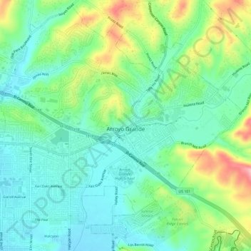
Name: Arroyo Grande topographic map, elevation, terrain.
Average elevation: 171 ft
Minimum elevation: 13 ft
Maximum elevation: 486 ft
San Luis Obispo County trails, hiking, mountain biking, running and outdoor activities
Other topographic maps
Click on a map to view its topography, its elevation and its terrain.
Marine Terrace
United States > California > San Luis Obispo County > Cambria
Average elevation: 128 ft
Arroyo Grande
United States > California > San Luis Obispo County > Arroyo Grande > Arroyo Grande
Average elevation: 184 ft
Grover Beach
United States > California > San Luis Obispo County > Grover Beach > Grover Beach
Average elevation: 118 ft
Avila Beach
United States > California > San Luis Obispo County
The beach is less than 0.5 miles (0.8 km) long and sheltered in San Luis Bay, which is formed by Point San Luis on the west and Fossil Point on the east. Avila Beach faces south and the 600 foot elevation of Point San Luis breaks the prevailing northwesterly winds. It is therefore usually warmer than the other…
Average elevation: 151 ft
Morro Bay
United States > California > San Luis Obispo County > Morro Bay > Morro Bay
Average elevation: 118 ft
San Luis Obispo
United States > California > San Luis Obispo County > San Luis Obispo
Average elevation: 833 ft