
Adams County topographic map
Interactive map
Click on the map to display elevation.
About this map
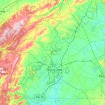
Name: Adams County topographic map, elevation, terrain.
Location: Adams County, Pennsylvania, United States (39.71977 -77.47109 40.06985 -76.95493)
Average elevation: 820 ft
Minimum elevation: 364 ft
Maximum elevation: 2,093 ft
Pennsylvania trails, hiking, mountain biking, running and outdoor activities
Other topographic maps
Click on a map to view its topography, its elevation and its terrain.
Lake Ontelaunee Dam
United States > Pennsylvania > Berks County > Ontelaunee Township
Average elevation: 325 ft
Shavertown
United States > Pennsylvania > Luzerne County > Kingston Township
Average elevation: 1,158 ft
Richeyville
United States > Pennsylvania > Washington County > Centerville
Average elevation: 1,138 ft
Buck Hill Falls
United States > Pennsylvania > Monroe County > Barrett Township > Mountainhome
Average elevation: 1,247 ft
Lewis Rocks
United States > Pennsylvania > Cumberland County > Southampton Township
Average elevation: 1,516 ft
Danielsville
United States > Pennsylvania > Northampton County > Lehigh Township
Average elevation: 833 ft
Chickies Rock
United States > Pennsylvania > Lancaster County > West Hempfield Township
Average elevation: 348 ft
Sunset Rocks
United States > Pennsylvania > Cumberland County > Cooke Township
Average elevation: 1,171 ft
Vestaburg
United States > Pennsylvania > Washington County > East Bethlehem Township
Average elevation: 1,010 ft
Blainsport
United States > Pennsylvania > Lancaster County > West Cocalico Township
Average elevation: 571 ft
Torrance
United States > Pennsylvania > Westmoreland County > Derry Township
Average elevation: 1,214 ft
Hemlock Farms
United States > Pennsylvania > Pike County > Blooming Grove Township
Average elevation: 1,434 ft
Great Wolf Lodge Water Park
United States > Pennsylvania > Monroe County > Pocono Township > Scotrun
Average elevation: 1,161 ft
Huntingdon Valley
United States > Pennsylvania > Montgomery County > Lower Moreland Township
Average elevation: 213 ft
Moween
United States > Pennsylvania > Westmoreland County > Loyalhanna Township
Average elevation: 1,047 ft
Bakersville
United States > Pennsylvania > Cambria County > Cambria Township
Average elevation: 2,175 ft
Pipersville
United States > Pennsylvania > Bucks County > Bedminster Township
Average elevation: 410 ft
Lambs Creek
United States > Pennsylvania > Tioga County > Richmond Township
Average elevation: 1,493 ft
Somers Lane
United States > Pennsylvania > Tioga County > Lawrence Township
Average elevation: 1,237 ft
Wech Corners
United States > Pennsylvania > Luzerne County > Wright Township
Average elevation: 1,375 ft
Blue Mountain
United States > Pennsylvania > Schuylkill County > West Penn Township
The ridge of Blue Mountain runs for 150 miles (240 km) through Pennsylvania, reaching an elevation of 2,270 feet (690 m) above sea level just north of the Pennsylvania Turnpike, near the borough of Newburg. Most of the ridgecrest, however, only reaches between 1,400 and 1,700 feet (430 and 520 m) in elevation.…
Average elevation: 823 ft
Washington Crossing
United States > Pennsylvania > Bucks County > Upper Makefield Township
Average elevation: 118 ft
Moosic Lakes
United States > Pennsylvania > Lackawanna County > Jefferson Township
Average elevation: 2,024 ft
Eagle Rock
United States > Pennsylvania > Lancaster County > Elizabeth Township
Average elevation: 633 ft
Upper Black Eddy
United States > Pennsylvania > Bucks County > Bridgeton Township
Average elevation: 328 ft
Town Hill
United States > Pennsylvania > Luzerne County > Huntington Township
Average elevation: 922 ft
Mount Cobb
United States > Pennsylvania > Lackawanna County > Jefferson Township
Average elevation: 1,736 ft
Crestwood
United States > Pennsylvania > Lackawanna County > Roaring Brook Township
Average elevation: 1,680 ft
Pennsville
United States > Pennsylvania > Northampton County > Lehigh Township
Average elevation: 627 ft
Lake Wesauking
United States > Pennsylvania > Bradford County > Wysox Township
Average elevation: 1,165 ft
Windham Summit
United States > Pennsylvania > Bradford County > Windham Township
Average elevation: 1,411 ft
Whitehorse
United States > Pennsylvania > Chester County > Willistown Township
Average elevation: 384 ft
Alice
United States > Pennsylvania > Westmoreland County > Mount Pleasant Township
Average elevation: 1,476 ft
Sunrise Lake
United States > Pennsylvania > Pike County > Dingman Township
Average elevation: 1,365 ft
Solomon Gap
United States > Pennsylvania > Luzerne County > Fairview Township > Fairview
Average elevation: 1,572 ft
Alverton
United States > Pennsylvania > Westmoreland County > East Huntingdon Township
Average elevation: 1,184 ft
Mount Hope
United States > Pennsylvania > Adams County > Hamiltonban Township
Average elevation: 1,296 ft
Hazel Kirk
United States > Pennsylvania > Washington County > Carroll Township
Average elevation: 1,020 ft
Port Bowkley
United States > Pennsylvania > Luzerne County > Plains Township > Plains
Average elevation: 581 ft
Nittany Valley
United States > Pennsylvania > Clinton County > Porter Township
Nittany Valley is in the western part of the Ridge and Valley province of the Appalachian Mountains. During the Appalachian orogeny, the sedimentary rock layers folded up into the Nittany Arch anticline. The arch was an ancient Himalayan scale mountain that towered above what is now the valley. The oldest rock…
Average elevation: 1,188 ft
Indian Rocks
United States > Pennsylvania > Lancaster County > East Cocalico Township
Average elevation: 528 ft
Madisonville
United States > Pennsylvania > Lackawanna County > Madison Township
Average elevation: 1,680 ft
Lake Harmony
United States > Pennsylvania > Carbon County > Kidder Township > Lake Harmony
Average elevation: 1,864 ft
Tinkwig Dam
United States > Pennsylvania > Pike County > Lackawaxen Township
Average elevation: 1,201 ft
Georgetown
United States > Pennsylvania > Luzerne County > Wilkes-Barre Township
Average elevation: 876 ft
Sand Springs
United States > Pennsylvania > Mifflin County > Bratton Township
Average elevation: 1,473 ft
Fredericktown
United States > Pennsylvania > Washington County > East Bethlehem Township
Average elevation: 1,004 ft
Pilgrim Gardens
United States > Pennsylvania > Delaware County > Haverford Township
Average elevation: 249 ft
Eagleville
United States > Pennsylvania > Montgomery County > Lower Providence Township
Average elevation: 335 ft
Millsboro
United States > Pennsylvania > Washington County > East Bethlehem Township
Average elevation: 1,010 ft
Rosegarden
United States > Pennsylvania > Cumberland County > Upper Allen Township
Average elevation: 469 ft
Glen Moore
United States > Pennsylvania > Lancaster County > Manheim Township
Average elevation: 358 ft
Duckrun
United States > Pennsylvania > Lawrence County > Shenango Township
Average elevation: 1,217 ft
Enterprise
United States > Pennsylvania > Washington County > South Strabane Township
Average elevation: 1,096 ft
Heart Lake
United States > Pennsylvania > Susquehanna County > Bridgewater Township
Average elevation: 1,581 ft
Shirks Corner
United States > Pennsylvania > Montgomery County > Upper Salford Township
Average elevation: 262 ft
East New Castle
United States > Pennsylvania > Lawrence County > Shenango Township
Average elevation: 1,043 ft
Walbert
United States > Pennsylvania > Lehigh County > South Whitehall Township
Average elevation: 449 ft
Grove Hill
United States > Pennsylvania > Clinton County > West Keating Township
Average elevation: 1,522 ft
Christian Corner
United States > Pennsylvania > Carbon County > Lower Towamensing Township
Average elevation: 741 ft
Patience
United States > Pennsylvania > Bedford County > Cumberland Valley Township
Average elevation: 1,522 ft
Hickory
United States > Pennsylvania > Washington County > Mount Pleasant Township
Average elevation: 1,217 ft
White Deer
United States > Pennsylvania > Union County > White Deer Township
Average elevation: 548 ft
Susquehanna State Park
United States > Pennsylvania > Lycoming County > Williamsport
Average elevation: 676 ft
Perkiomen Place
United States > Pennsylvania > Montgomery County > East Greenville
Average elevation: 367 ft