
Sylvania topographic map
Interactive map
Click on the map to display elevation.
About this map
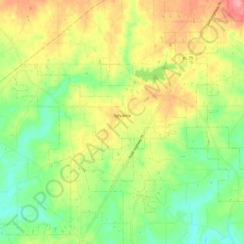
Name: Sylvania topographic map, elevation, terrain.
Location: Sylvania, DeKalb County, Alabama, 35988, United States (34.52887 -85.85662 34.59101 -85.75470)
Average elevation: 1,329 ft
Minimum elevation: 1,178 ft
Maximum elevation: 1,516 ft
DeKalb County trails, hiking, mountain biking, running and outdoor activities
Other topographic maps
Click on a map to view its topography, its elevation and its terrain.
Mentone
United States > Alabama > DeKalb County
Mentone is a town in DeKalb County, Alabama, United States. Mentone, located atop Lookout Mountain, has the highest elevation of any incorporated town in Alabama, and narrowly higher than Hytop.
Average elevation: 1,542 ft