
Marana topographic map
Interactive map
Click on the map to display elevation.
Marana
Marana has a hot semi-arid climate (Köppen climate classification BSh). This is characterized by hot summers and relatively mild winters. The area averages only 12.19 inches (310 mm) of annual rainfall. During the dry and sunny winter months, daytime highs usually reach between 60°F and 70°F (16°C and 21°C), with temperatures cooling to well below 50°F (10°C), and sometimes below 40°F (4°C) during the night. Temperatures below the freezing mark are not uncommon during this period. In the summer, high temperatures range between 95°F and 105°F (35°C and 41°C), with nights cooling down to around 70°F (21°C). The occasional heat wave can cause temperatures to soar above 110°F (43°C) for multiple days during the hot summer months. Rain is much more frequent during the summer due to the North American Monsoon, and is sometimes accompanied by high winds and thunderstorms. Due to its lower elevation and less pronounced urban heat island effect, Marana generally sees slightly warmer daytime temperatures and cooler nighttime temperatures than Tucson.
About this map
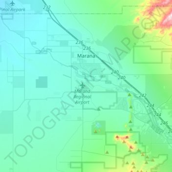
Name: Marana topographic map, elevation, terrain.
Location: Marana, Pima County, Arizona, United States (32.30870 -111.28721 32.51138 -111.02913)
Average elevation: 2,156 ft
Minimum elevation: 1,860 ft
Maximum elevation: 4,134 ft
Pima County trails, hiking, mountain biking, running and outdoor activities
Other topographic maps
Click on a map to view its topography, its elevation and its terrain.
Tucson
United States > Arizona > Pima County > Tucson
The city's elevation is 2,643 ft (806 m) above sea level (as measured at the Tucson International Airport). Tucson is on an alluvial plain in the Sonoran Desert, surrounded by five minor ranges of mountains: the Santa Catalina Mountains and the Tortolita Mountains to the north, the Santa Rita Mountains to the…
Average elevation: 2,743 ft