
Make a donation
Gear up for your next adventure:
As an Amazon Associate, this site earns from qualifying purchases at no extra cost to you.
Corona de Tucson topographic map
Click on the map to display elevation.
Make a donation
Gear up for your next adventure:
As an Amazon Associate, this site earns from qualifying purchases at no extra cost to you.
About this map
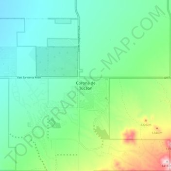
Name: Corona de Tucson topographic map, elevation, terrain.
Average elevation: 3,369 ft
Minimum elevation: 3,123 ft
Maximum elevation: 3,822 ft
Pima County trails, hiking, mountain biking, running and outdoor activities
Make a donation
Gear up for your next adventure:
As an Amazon Associate, this site earns from qualifying purchases at no extra cost to you.
Other topographic maps
Click on a map to view its topography, its elevation and its terrain.
Tucson
United States > Arizona > Pima County
Tucson is situated on an alluvial plain in the Sonoran Desert, at an elevation of approximately 2,400 feet (730 meters) above sea level. The city is enveloped by five mountain ranges, which contribute significantly to its varied topography. To the north lie the Santa Catalina and Tortolita Mountains, while the…
Average elevation: 2,697 ft
Tucson
United States > Arizona > Pima County
By 1900, 7,531 people lived in Tucson. By 1910, the population increased to 13,913. At about this time, the U.S. Veterans Administration had begun construction of the present Veterans Hospital. The city's clean, dry air made it a destination for the many veterans who had been gassed in World War I and needed…
Average elevation: 2,697 ft
Oro Valley
United States > Arizona > Pima County
Oro Valley is located at 32°25′N 110°59′W / 32.417°N 110.983°W / 32.417; -110.983 (32.4212, −110.9760) in the middle Cañada del Oro Valley. Oro Valley sits at an average elevation of 2,620 feet (800 m) above sea level.
Average elevation: 3,179 ft
Saguaro National Park
United States > Arizona > Pima County
Both districts conserve tracts of the Sonoran Desert, including ranges of significant hills, the Tucson Mountains in the west and the Rincon Mountains in the east. Elevations in the Tucson Mountain District range from 2,180 to 4,687 feet (664 to 1,429 m), the summit of Wasson Peak. Elevations within the Rincon…
Average elevation: 3,852 ft
Make a donation
Gear up for your next adventure:
As an Amazon Associate, this site earns from qualifying purchases at no extra cost to you.
Catalina State Park
United States > Arizona > Pima County
Catalina State Park is located at the base of the Santa Catalina Mountains. It is home to nearly 5,000 saguaros and desert plants. There are 5,500 acres of foothills and canyons that offer opportunities for camping, hiking, and bird watching. The park is home to more than 150 species. At an elevation of nearly…
Average elevation: 2,972 ft
Marana
United States > Arizona > Pima County
Marana has a hot semi-arid climate (Köppen climate classification BSh). This is characterized by hot summers and relatively mild winters. The area averages only 12.19 inches (310 mm) of annual rainfall. During the dry and sunny winter months, daytime highs usually reach between 60°F and 70°F (16°C and…
Average elevation: 2,156 ft
Make a donation
Gear up for your next adventure:
As an Amazon Associate, this site earns from qualifying purchases at no extra cost to you.
Make a donation
Gear up for your next adventure:
As an Amazon Associate, this site earns from qualifying purchases at no extra cost to you.
Marana
United States > Arizona > Pima County
Marana has a hot semi-arid climate (Köppen climate classification BSh). This is characterized by hot summers and relatively mild winters. The area averages only 12.19 inches (310 mm) of annual rainfall. During the dry and sunny winter months, daytime highs usually reach between 60°F and 70°F (16°C and…
Average elevation: 2,165 ft
Make a donation
Gear up for your next adventure:
As an Amazon Associate, this site earns from qualifying purchases at no extra cost to you.
Saguaro National Park
United States > Arizona > Pima County
Both districts conserve tracts of the Sonoran Desert, including ranges of significant hills, the Tucson Mountains in the west and the Rincon Mountains in the east. Elevations in the Tucson Mountain District range from 2,180 to 4,687 feet (664 to 1,429 m), the summit of Wasson Peak. Elevations within the Rincon…
Average elevation: 3,852 ft
Make a donation
Gear up for your next adventure:
As an Amazon Associate, this site earns from qualifying purchases at no extra cost to you.
Marana
United States > Arizona > Pima County
Marana has a hot semi-arid climate (Köppen climate classification BSh). This is characterized by hot summers and relatively mild winters. The area averages only 12.19 inches (310 mm) of annual rainfall. During the dry and sunny winter months, daytime highs usually reach between 60 and 70 °F (16 and 21 °C),…
Average elevation: 2,165 ft
Make a donation
Gear up for your next adventure:
As an Amazon Associate, this site earns from qualifying purchases at no extra cost to you.
Oro Valley
United States > Arizona > Pima County
Oro Valley is located at 32°25′N 110°59′W / 32.417°N 110.983°W / 32.417; -110.983 (32.4212, −110.9760) in the middle of the Cañada del Oro Valley. Oro Valley sits at an average elevation of 2,620 feet (800 m) above sea level.
Average elevation: 3,179 ft
Tucson
United States > Arizona > Pima County
By 1900, Tucson had 7,531 residents. By 1910, the population increased to 13,913. About this time, the U.S. Veterans Administration had begun construction of the present Veterans Hospital. The city's clean, dry air made it a destination for many veterans who had been gassed in World War I and needed…
Average elevation: 2,697 ft
Make a donation
Gear up for your next adventure:
As an Amazon Associate, this site earns from qualifying purchases at no extra cost to you.
Tucson
United States > Arizona > Pima County
By 1900, 7,531 people lived in Tucson. By 1910, the population increased to 13,913. About this time, the U.S. Veterans Administration had begun construction of the present Veterans Hospital. The city's clean, dry air made it a destination for many veterans who had been gassed in World War I and needed…
Average elevation: 2,697 ft
Saguaro National Park
United States > Arizona > Pima County
Both districts conserve tracts of the Sonoran Desert, including ranges of significant hills, the Tucson Mountains in the west and the Rincon Mountains in the east. Elevations in the Tucson Mountain District range from 2,180 to 4,687 feet (664 to 1,429 m), the summit of Wasson Peak. Elevations within the Rincon…
Average elevation: 3,852 ft
Oro Valley
United States > Arizona > Pima County
Oro Valley is located at 32°25′N 110°59′W / 32.417°N 110.983°W / 32.417; -110.983 (32.4212, −110.9760) in the middle of the Cañada del Oro Valley. Oro Valley sits at an average elevation of 2,620 feet (800 m) above sea level.
Average elevation: 3,179 ft
Make a donation
Gear up for your next adventure:
As an Amazon Associate, this site earns from qualifying purchases at no extra cost to you.
Saguaro National Park
United States > Arizona > Pima County
Both districts conserve tracts of the Sonoran Desert, including ranges of significant hills, the Tucson Mountains in the west and the Rincon Mountains in the east. Elevations in the Tucson Mountain District range from 2,180 to 4,687 feet (664 to 1,429 m), the summit of Wasson Peak. Elevations within the Rincon…
Average elevation: 3,852 ft
Brandi Fenton Memorial Park
United States > Arizona > Pima County > Tucson
Average elevation: 2,405 ft
Make a donation
Gear up for your next adventure:
As an Amazon Associate, this site earns from qualifying purchases at no extra cost to you.
Tucson
United States > Arizona > Pima County
By 1900, 7,531 people lived in Tucson. By 1910, the population increased to 13,913. About this time, the U.S. Veterans Administration had begun construction of the present Veterans Hospital. The city's clean, dry air made it a destination for many veterans who had been gassed in World War I and needed…
Average elevation: 2,697 ft
Oro Valley
United States > Arizona > Pima County
Oro Valley is located at 32°25′N 110°59′W / 32.417°N 110.983°W / 32.417; -110.983 (32.4212, −110.9760) in the middle Cañada del Oro Valley. Oro Valley sits at an average elevation of 2,620 feet (800 m) above sea level.
Average elevation: 3,179 ft
Make a donation
Gear up for your next adventure:
As an Amazon Associate, this site earns from qualifying purchases at no extra cost to you.