Geolocate

Thingvellir topographic map

Interactive map

Click on the map to display elevation.

About this map

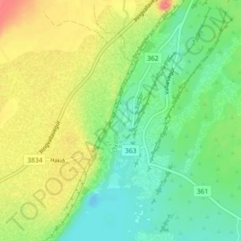
Name: Thingvellir topographic map, elevation, terrain.

Location: Thingvellir, Bláskógabyggð, Southern Region, Iceland (64.24907 -21.13110 64.26907 -21.11110)

Average elevation: 397 ft

Minimum elevation: 308 ft

Maximum elevation: 522 ft

Other topographic maps

Click on a map to view its topography, its elevation and its terrain.

Geysir

Iceland > Bláskógabyggð

Geysir, Haukadalsvegur, Bláskógabyggð, Southern Region, Iceland

Average elevation: 381 ft

Laugarvatn

Iceland > Bláskógabyggð > Laugarvatn

Laugarvatn, Bláskógabyggð, Southern Region, Iceland

Average elevation: 220 ft

Þingvellir National Park

Iceland > Bláskógabyggð

Þingvellir National Park, Bláskógabyggð, Southern Region, Iceland

Average elevation: 1,037 ft

Skjaldbreiður

Iceland > Bláskógabyggð

Skjaldbreiður, Bláskógabyggð, Southern Region, Iceland

Average elevation: 2,986 ft