
Ridgecrest topographic map
Interactive map
Click on the map to display elevation.
Ridgecrest
Walker Pass (elevation 5,250 ft (1.60 km)) is a mountain pass by Lake Isabella in the southern Sierra Nevada mountains. It is located in northeastern Kern County, approximately 53 mi (85 km) ENE of Bakersfield and 10 mi (16 km) WSW of Ridgecrest. The pass provides a route between the San Joaquin Valley on the west and the Mojave Desert on the east.
About this map
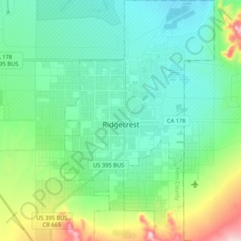
Name: Ridgecrest topographic map, elevation, terrain.
Location: Ridgecrest, Kern County, California, 93555, United States (35.56389 -117.70579 35.68079 -117.61640)
Average elevation: 2,425 ft
Minimum elevation: 2,185 ft
Maximum elevation: 3,215 ft
Kern County trails, hiking, mountain biking, running and outdoor activities
Other topographic maps
Click on a map to view its topography, its elevation and its terrain.
Mettler
United States > California > Kern County > Mettler
Mettler is 25 miles (40 km) south of Bakersfield.[1] The locality has an area of 0.2 square miles (0.52 km2) and an elevation of 541 feet (165 m).
Average elevation: 538 ft
Frazier Park
United States > California > Kern County
Frazier Park is a village and unincorporated community in Kern County, California. It is 5 miles (8 km) west of Lebec, at an elevation of 4,639 feet (1,414 m). It is one of the Mountain Communities of the Tejon Pass. The population was 2,592 in the 2020 census, down from 2,691 in 2010.
Average elevation: 5,030 ft
Lost Hills
United States > California > Kern County
Lost Hills (formerly, Lost Hill) is a census-designated place (CDP) in Kern County, California, United States. Lost Hills is located 42 miles (68 km) west-northwest of Bakersfield, at an elevation of 305 feet (93 m). The population was 2,412 at the 2010 census, up from 1,938 at the 2000 census.
Average elevation: 269 ft
Miracle Hot Springs
United States > California > Kern County > Bodfish > Miracle Hot Springs
Average elevation: 2,818 ft
Wofford Heights
United States > California > Kern County
Wofford Heights is a census-designated place (CDP) in the southern Sierra Nevada, in Kern County, California, United States. Wofford Heights is located in the west Kern River Valley, 3.5 miles (5.6 km) south-southwest of Kernville, at an elevation of 2,684 feet (818 m). The population was 2,200 at the 2010…
Average elevation: 3,655 ft
Frazier Park
United States > California > Kern County
Frazier Park is an unincorporated community in Kern County, California. It is 5 miles (8 km) west of Lebec, at an elevation of 4,639 feet (1,414 m). It is one of the Mountain Communities of the Tejon Pass. The population was 2,691 in the 2010 census, up from 2,348 in 2000.
Average elevation: 5,030 ft
Woodford
United States > California > Kern County
Keene (formerly, Wells) is a census-designated place (CDP) in Kern County, California in the foothills of the Tehachapi Mountains at the southern extreme of the San Joaquin Valley. Keene is located 8.5 miles (14 km) northwest of Tehachapi, at an elevation of 2,602 feet (793 m). The population was 469 at the…
Average elevation: 2,949 ft
Keene
United States > California > Kern County
Keene (formerly, Wells) is a census-designated place (CDP) in Kern County, California in the foothills of the Tehachapi Mountains at the southern extreme of the San Joaquin Valley. Keene is located 8.5 miles (14 km) northwest of Tehachapi, at an elevation of 2,602 feet (793 m). The population was 469 at the…
Average elevation: 2,927 ft
Onyx
United States > California > Kern County
Onyx (formerly, Scodie) is a census-designated place (CDP) in Kern County, California, United States. Onyx is located 3.5 miles (6 km) east-northeast of Weldon in the South Fork Valley at an elevation of 2,795 feet (852 m). The population was 475 at the 2010 census, down from 476 at the 2000 census.
Average elevation: 3,953 ft
Frazier Park
United States > California > Kern County
Frazier Park is an unincorporated community and census-designated place in Kern County, California. It is 5 miles (8 km) west of Lebec, at an elevation of 4,639 feet (1,414 m). It is one of the Mountain Communities of the Tejon Pass. The population was 2,592 in the 2020 census, down from 2,691 in 2010.
Average elevation: 5,030 ft
McKittrick
United States > California > Kern County
McKittrick is a census-designated place (CDP) in Kern County, California, United States. McKittrick is located 14 miles (23 km) northwest of Taft, at an elevation of 1,056 feet (322 m). The population was 115 at the 2010 census, down from 160 at the 2000 census.
Average elevation: 1,273 ft
China Lake
United States > California > Kern County > Ridgecrest > China Lake
Average elevation: 2,260 ft
Kernville
United States > California > Kern County > Kernville
Kernville is a census-designated place (CDP) in the southern Sierra Nevada, in Kern County, California, United States. Kernville is located 42 miles (68 km) northeast of Bakersfield, at an elevation of 2,667 feet (813 m). The population was 1,549 at the 2020 United States census, up from 1,395 at the 2010…
Average elevation: 3,724 ft
Lebec
United States > California > Kern County
According to the United States Census Bureau, Lebec has an area of 15.3 square miles (40 km2). The community, which is near Tejon Pass, lies at an elevation of 3,481 feet (1,061 m).
Average elevation: 3,812 ft
Pine Mountain Club
United States > California > Kern County
Pine Mountain Club has an area of 16.7 square miles (43.25 km2). It ranges from 4,901 to 6,400 feet (1,494 to 1,951 m) in elevation. The community sits in a deep valley of the San Emigdio Mountains, on the San Andreas fault. It is surrounded by Los Padres National Forest. The settlement lies between Apache…
Average elevation: 6,125 ft
Edwards Air Force Base
United States > California > Kern County
Ground tests began five days after the first XP-59 arrived on 21 September 1942. First flight took place on 30 September when the XP-59 rose to 10 feet (3.0 m) altitude for 0.5 miles (0.80 km) during taxi testing. However, the first official flight was 1 October 1942 with NACA, Navy Bureau of Aeronautics,…
Average elevation: 2,395 ft