
Saint-Sauveur topographic map
Interactive map
Click on the map to display elevation.
About this map
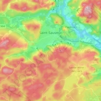
Name: Saint-Sauveur topographic map, elevation, terrain.
Average elevation: 965 ft
Minimum elevation: 505 ft
Maximum elevation: 1,453 ft
Other topographic maps
Click on a map to view its topography, its elevation and its terrain.
Saint-Michel-de-Wentworth
Canada > Quebec > Les Pays-d'en-Haut > Wentworth-Nord
Average elevation: 1,050 ft
Lac Saint-Louis
Canada > Quebec > Les Pays-d'en-Haut > Sainte-Marguerite-du-Lac-Masson
Average elevation: 1,453 ft
Lac Valiquette
Canada > Quebec > Les Pays-d'en-Haut > Saint-Adolphe-d'Howard
Average elevation: 1,490 ft
Lac Marier
Canada > Quebec > Les Pays-d'en-Haut > Sainte-Marguerite-du-Lac-Masson
Average elevation: 1,237 ft
Domaine-Alpine
Canada > Quebec > Les Pays-d'en-Haut > Saint-Adolphe-d'Howard
Average elevation: 1,283 ft
Mont Edward
Canada > Quebec > Les Pays-d'en-Haut > Sainte-Marguerite-du-Lac-Masson
Average elevation: 1,414 ft