
Saint Augustine topographic map
Interactive map
Click on the map to display elevation.
Saint Augustine
Saint Augustine is characterized by a diverse topography that features a mix of coastal and inland landscapes. Situated along the eastern coast of the state, the city lies on a narrow peninsula bordered by the Atlantic Ocean to the east and the Matanzas River to the west. The area includes sandy beaches that stretch for miles, providing a gentle slope from the ocean into the urban environment. Inland, the terrain is relatively flat, interspersed with marshlands and small water bodies that support a rich ecosystem. The elevation is generally low, rarely exceeding 30 feet above sea level, contributing to the region's susceptibility to flooding during storms. Overall, the topography of Saint Augustine is defined by its coastal features, scenic waterways, and lush, subtropical vegetation, making it a unique blend of natural beauty and historical charm.
About this map
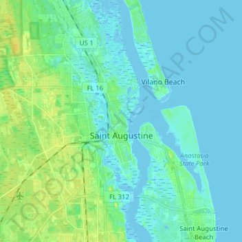
Name: Saint Augustine topographic map, elevation, terrain.
Average elevation: 16 ft
Minimum elevation: -10 ft
Maximum elevation: 59 ft
Saint Johns County trails, hiking, mountain biking, running and outdoor activities
Other topographic maps
Click on a map to view its topography, its elevation and its terrain.
Ponte Vedra Beach
United States > Florida > Saint Johns County > Ponte Vedra Beach
Ponte Vedra Beach is characterized by its gently rolling terrain that is primarily flat and lies only about 15 feet above sea level. The landscape is predominantly shaped by coastal dunes and the proximity to the Atlantic Ocean, resulting in sandy beaches interspersed with vegetation typical of barrier island…
Average elevation: 10 ft
Anastasia Island
United States > Florida > Saint Johns County > Saint Augustine
Average elevation: 13 ft
Ponte Vedra Beach
United States > Florida > Saint Johns County > Ponte Vedra Beach
Average elevation: 10 ft
West Augustine
United States > Florida > Saint Johns County > Saint Augustine
Average elevation: 20 ft