
Carmel-by-the-Sea topographic map
Interactive map
Click on the map to display elevation.
About this map
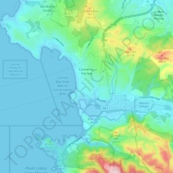
Name: Carmel-by-the-Sea topographic map, elevation, terrain.
Average elevation: 253 ft
Minimum elevation: -13 ft
Maximum elevation: 1,385 ft
Monterey County trails, hiking, mountain biking, running and outdoor activities
Other topographic maps
Click on a map to view its topography, its elevation and its terrain.
Julia Pfieffer Burns Vista Point
United States > California > Monterey County
Average elevation: 623 ft
Big Sur
United States > California > Monterey County
The highest peaks of the crest of the coast range are located at an average distance from the coast of three and a half miles [5.6 km]. In this distance they rise to elevations of from three thousand six hundred to five thousand feet [1,100 to 1,500 m] above the sea-level. From San Carpoforo Creek to…
Average elevation: 633 ft
Point Sur Lighthouse
United States > California > Monterey County > Big Sur Village
Average elevation: 36 ft
Big Sur
United States > California > Monterey County
The highest peaks of the crest of the coast range are located at an average distance from the coast of three and a half miles [5.6 km]. In this distance they rise to elevations of from three thousand six hundred to five thousand feet [1,100 to 1,500 m] above the sea-level. From San Carpoforo Creek to…
Average elevation: 633 ft
Pebble Beach
United States > California > Monterey County > Del Monte Forest
Average elevation: 174 ft
Las Lomas
United States > California > Monterey County > Las Lomas > Hutchings Gate
Las Lomas (Spanish for 'The Hills') is an unincorporated community and census-designated place (CDP) in Monterey County, California, United States. Las Lomas is located 7 miles (11 km) north-northwest of Prunedale. The elevation is 43 feet (13 m). The population was 3,046 at the 2020 census.
Average elevation: 115 ft
Carmel Pinnacles State Marine Reserve
United States > California > Monterey County > Del Monte Forest
Average elevation: 7 ft
Schoonover Park
United States > California > Monterey County > East Garrison
Average elevation: 190 ft
Prunedale
United States > California > Monterey County
Prunedale is a census-designated place in Monterey County, California, United States. It is located 8 miles (13 km) north of Salinas at an elevation of 92 feet (28 m). The population was 18,885 as of the 2020 census, up from 17,560 in 2010. Plum trees were grown in Prunedale in the early days of its founding,…
Average elevation: 226 ft
Pebble Beach
United States > California > Monterey County > Del Monte Forest
Average elevation: 174 ft
King City
United States > California > Monterey County
King City (variants: Kings City, City of King) is a city in Monterey County, California, United States. It is located on the Salinas River 51 miles (82 km) southeast of Salinas, at an elevation of 335 feet (102 m). It lies along U.S. Route 101 in the Salinas Valley of California's Central Coast. King City is a…
Average elevation: 335 ft