
Parkway topographic map
Interactive map
Click on the map to display elevation.
About this map
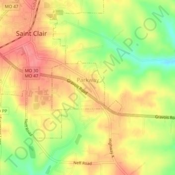
Name: Parkway topographic map, elevation, terrain.
Location: Parkway, Franklin County, Missouri, United States (38.33281 -90.97701 38.34096 -90.96314)
Average elevation: 699 ft
Minimum elevation: 554 ft
Maximum elevation: 794 ft
Franklin County trails, hiking, mountain biking, running and outdoor activities
Other topographic maps
Click on a map to view its topography, its elevation and its terrain.
Lake Saint Clair Number Three Dam
United States > Missouri > Franklin County
Average elevation: 705 ft