
Essex Fells topographic map
Interactive map
Click on the map to display elevation.
About this map
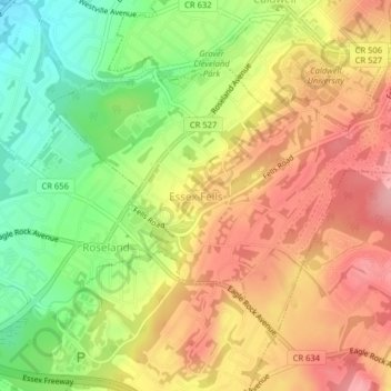
Name: Essex Fells topographic map, elevation, terrain.
Location: Essex Fells, Essex County, New Jersey, 07021, United States (40.81388 -74.29970 40.83529 -74.25979)
Average elevation: 427 ft
Minimum elevation: 197 ft
Maximum elevation: 623 ft
Essex County trails, hiking, mountain biking, running and outdoor activities
Other topographic maps
Click on a map to view its topography, its elevation and its terrain.
Eagle Rock Reservation
United States > New Jersey > Essex County > West Orange
Average elevation: 472 ft
Mills Reservation
United States > New Jersey > Essex County > Montclair > Montclair Heights
Average elevation: 397 ft
Cedar Grove
United States > New Jersey > Essex County > Cedar Grove
The township is located between the First and Second Watchung Mountains. The center of the township is in a valley that is about 280 feet (85 m) above sea level; however, many sections of Cedar Grove are well above 400 feet (120 m), including the Park Ridge Estates, the abandoned Essex County Hospital Center,…
Average elevation: 354 ft