
Make a donation
Gear up for your next adventure:
As an Amazon Associate, this site earns from qualifying purchases at no extra cost to you.
Lake Moraine topographic map
Click on the map to display elevation.
Make a donation
Gear up for your next adventure:
As an Amazon Associate, this site earns from qualifying purchases at no extra cost to you.
About this map
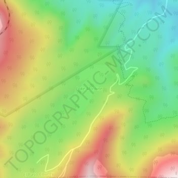
Name: Lake Moraine topographic map, elevation, terrain.
Location: Lake Moraine, El Paso County, Colorado, United States (38.80775 -104.99955 38.81570 -104.99090)
Average elevation: 10,377 ft
Minimum elevation: 9,521 ft
Maximum elevation: 11,539 ft
El Paso County trails, hiking, mountain biking, running and outdoor activities
Make a donation
Gear up for your next adventure:
As an Amazon Associate, this site earns from qualifying purchases at no extra cost to you.
Other topographic maps
Click on a map to view its topography, its elevation and its terrain.
Garden of the Gods
United States > Colorado > El Paso County > Colorado Springs
Average elevation: 6,463 ft
Colorado Springs
United States > Colorado > El Paso County
Snowfall is usually moderate and remains on the ground briefly because of direct sun, with the city receiving 38 inches (97 cm) per season, although the mountains to the west often receive in excess of triple that amount; March is the snowiest month in the region, both by total accumulation and number of days…
Average elevation: 7,313 ft
Stratton Meadows
United States > Colorado > El Paso County > Colorado Springs
Average elevation: 5,968 ft
Make a donation
Gear up for your next adventure:
As an Amazon Associate, this site earns from qualifying purchases at no extra cost to you.
Make a donation
Gear up for your next adventure:
As an Amazon Associate, this site earns from qualifying purchases at no extra cost to you.
Make a donation
Gear up for your next adventure:
As an Amazon Associate, this site earns from qualifying purchases at no extra cost to you.
Ben Lomand Mountain
United States > Colorado > El Paso County > Palmer Lake
Average elevation: 7,283 ft
Make a donation
Gear up for your next adventure:
As an Amazon Associate, this site earns from qualifying purchases at no extra cost to you.
Green Mountain Falls
United States > Colorado > El Paso County > Green Mountain Falls
Average elevation: 8,481 ft
Make a donation
Gear up for your next adventure:
As an Amazon Associate, this site earns from qualifying purchases at no extra cost to you.