Geolocate

Woodmoor topographic map

Interactive map

Click on the map to display elevation.

About this map

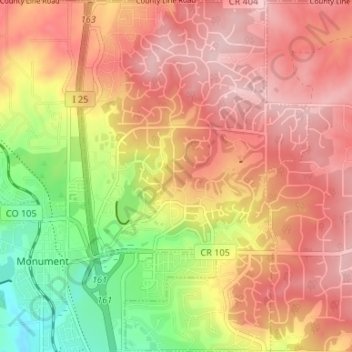
Name: Woodmoor topographic map, elevation, terrain.

Location: Woodmoor, El Paso County, Colorado, 80132, United States (39.07834 -104.86579 39.12989 -104.82251)

Average elevation: 7,251 ft

Minimum elevation: 6,860 ft

Maximum elevation: 7,513 ft

Routes: El Paso County GPS tracks, routes, trails, hikes

Other topographic maps

Click on a map to view its topography, its elevation and its terrain.

Colorado Springs

United States > Colorado > El Paso County

Colorado Springs boasts a diverse and striking topography characterized by its high elevation and mountainous terrain. Nestled at approximately 6,035 feet (1,839 meters) above sea level, the city is flanked by the majestic Pikes Peak, which rises dramatically to 14,115 feet (4,302 meters), forming part of the…

Average elevation: 7,388 ft

Air Force Academy

United States > Colorado > El Paso County > Colorado Springs

The campus of the academy covers 18,455 acres (29 sq mi; 75 km2) on the east side of the Rampart Range of the Rocky Mountains, just north of Colorado Springs. Its elevation is normally given as 7,258 feet (2,212 m) above sea level, which is at the cadet area. The academy was designed by Skidmore, Owings and…

Average elevation: 7,080 ft

Palmer Lake

United States > Colorado > El Paso County

The town marks the top of the Palmer Divide, a ridge running from Palmer Lake eastward which separates the Arkansas River drainage to the south from the Platte River drainage to the north. The highest point of the divide is about 7,700 feet (2,300 m) above sea level at Vollmer Hill located in the Black Forest.…

Average elevation: 7,552 ft

Pikes Peak

United States > Colorado > El Paso County

Soils on Pikes Peak above the timberline (approximately 12,000 ft or 3,700 m) are classified as Cirque land. Forests at lower altitudes mostly lie over the brown stony, sandy, loams of the Catamount loam or Ivywild loam series.

Average elevation: 12,802 ft

Fort Carson

United States > Colorado > El Paso County

Average elevation: 5,860 ft

Fountain

United States > Colorado > El Paso County

Average elevation: 5,758 ft

Ramah

United States > Colorado > El Paso County

Average elevation: 6,122 ft

Fountain

United States > Colorado > El Paso County

Average elevation: 5,656 ft

Monument Lake

United States > Colorado > El Paso County > Monument

Average elevation: 6,998 ft

Chipita Park

United States > Colorado > El Paso County

Average elevation: 8,468 ft

Colorado Springs

United States > Colorado > El Paso County

Snowfall is usually moderate and remains on the ground briefly because of direct sun, with the city receiving 38 inches (97 cm) per season, although the mountains to the west often receive in excess of triple that amount; March is the snowiest month in the region, both by total accumulation and number of days…

Average elevation: 7,313 ft

Gleneagle

United States > Colorado > El Paso County

Average elevation: 6,886 ft

Peyton

United States > Colorado > El Paso County

Average elevation: 6,824 ft

Monument

United States > Colorado > El Paso County

Monument experiences a hemiboreal continental climate (Köppen Dfb) with warm, relatively rainy summers and cold, snowy winters. As with many areas of Colorado, Monument experiences a lot of sunshine with an average of 250 sunny days per year. The semi-arid climate keeps the dew point very low in Monument…

Average elevation: 7,087 ft

Falcon

United States > Colorado > El Paso County > Falcon

Average elevation: 6,926 ft

Stratmoor

United States > Colorado > El Paso County

Average elevation: 5,840 ft

Yoder

United States > Colorado > El Paso County

Average elevation: 6,178 ft

Wigwam

United States > Colorado > El Paso County

Average elevation: 5,266 ft

Cheyenne Mountain

United States > Colorado > El Paso County

Average elevation: 8,543 ft

Security

United States > Colorado > El Paso County

Average elevation: 5,804 ft

Falcon

United States > Colorado > El Paso County

Average elevation: 6,877 ft

Stratmoor Hills

United States > Colorado > El Paso County

Average elevation: 5,902 ft

Gleneagle

United States > Colorado > El Paso County > Gleneagle

Average elevation: 6,886 ft

Calhan

United States > Colorado > El Paso County

Average elevation: 6,549 ft

Black Forest

United States > Colorado > El Paso County

Average elevation: 6,831 ft

Cascade

United States > Colorado > El Paso County

Average elevation: 8,179 ft

Glen Park

United States > Colorado > El Paso County > Palmer Lake

Average elevation: 7,615 ft

Manitou Springs

United States > Colorado > El Paso County

Average elevation: 7,034 ft

Colorado Springs

United States > Colorado > El Paso County

Average elevation: 6,880 ft

Cimarron Hills

United States > Colorado > El Paso County

Average elevation: 6,394 ft

Fountain

United States > Colorado > El Paso County

Average elevation: 5,656 ft

Lake Moraine

United States > Colorado > El Paso County

Average elevation: 10,377 ft

Rush

United States > Colorado > El Paso County > Rush

Average elevation: 6,020 ft

Rocky Mountain

United States > Colorado > El Paso County

Average elevation: 8,510 ft

Palmer Lake

United States > Colorado > El Paso County > Palmer Lake

Average elevation: 7,579 ft

Security-Widefield

United States > Colorado > El Paso County

Average elevation: 5,787 ft

Monument

United States > Colorado > El Paso County > Monument

Average elevation: 6,893 ft