
Make a donation
Gear up for your next adventure:
As an Amazon Associate, this site earns from qualifying purchases at no extra cost to you.
Atyrau Province topographic map
Click on the map to display elevation.
Make a donation
Gear up for your next adventure:
As an Amazon Associate, this site earns from qualifying purchases at no extra cost to you.
About this map
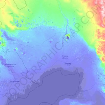
Name: Atyrau Province topographic map, elevation, terrain.
Location: Atyrau Province, Kazakhstan (45.06058 48.20620 50.26058 53.40620)
Average elevation: -7 ft
Minimum elevation: -105 ft
Maximum elevation: 781 ft
Make a donation
Gear up for your next adventure:
As an Amazon Associate, this site earns from qualifying purchases at no extra cost to you.
Other topographic maps
Click on a map to view its topography, its elevation and its terrain.
Aktobe
Kazakhstan > Aqtöbe region > Astana District
After the territories of modern Kazakhstan were annexed to the Russian Empire, due to the need for strong points and retail outlets, many cities appeared, one of which was Aktobe. In the architecture of the cities of Southern Kazakhstan, the influence of the Central Asian khanates is traced, and the…
Average elevation: 906 ft
Talgar
Kazakhstan > Almaty Region > Talgar District
Talgar has a total area of 18.8 square km (7.3 mi²). The grade of the town's built-up areas is consistent with the natural unevenness of its overall natural geography. The average land elevation is 1250 m above sea level. The lowest points are in the northern part of the town at 1000 m, while the highest…
Average elevation: 3,402 ft
Make a donation
Gear up for your next adventure:
As an Amazon Associate, this site earns from qualifying purchases at no extra cost to you.
Trans-Ili Alatau
Ile Alatau (Kazakh: Ile Alatauy, Іле Алатауы), also spelt as Trans-Ili Alatau, is a part of the Northern Tian Shan mountain system (ancient Mount Imeon) in Kazakhstan and Kyrgyzstan. It is the northernmost mountain range of Tian Shan, stretching for about 350 km (220 mi) with a maximal elevation of…
Average elevation: 6,755 ft
Make a donation
Gear up for your next adventure:
As an Amazon Associate, this site earns from qualifying purchases at no extra cost to you.
Park named after the First President of the Republic of Kazakhstan
Average elevation: 3,346 ft
Make a donation
Gear up for your next adventure:
As an Amazon Associate, this site earns from qualifying purchases at no extra cost to you.
Astana
Astana is located in central Kazakhstan on the Ishim River in a very flat, semi-arid steppe region which covers most of the country's territory. It is at 51° 10' north latitude and 71° 26' east longitude. The city encompasses 722.0 square kilometres (278.8 sq mi). The elevation of Astana is 347 metres (1,138…
Average elevation: 1,184 ft
Make a donation
Gear up for your next adventure:
As an Amazon Associate, this site earns from qualifying purchases at no extra cost to you.
Make a donation
Gear up for your next adventure:
As an Amazon Associate, this site earns from qualifying purchases at no extra cost to you.
Make a donation
Gear up for your next adventure:
As an Amazon Associate, this site earns from qualifying purchases at no extra cost to you.
Make a donation
Gear up for your next adventure:
As an Amazon Associate, this site earns from qualifying purchases at no extra cost to you.
Make a donation
Gear up for your next adventure:
As an Amazon Associate, this site earns from qualifying purchases at no extra cost to you.
Esil River
Kazakhstan > North Kazakhstan Region > Qyzyljar District > Рощин ауылдық округі > Ol'shanka
Average elevation: 322 ft
Balkhash
Balkhash was founded in 1937 as an industrial city centred on the mining and smelting of copper, which is still being exploited in the area. The city lies approximately 500 km west of the Chinese border, on the north side of the lake at an altitude of 440 m.
Average elevation: 1,463 ft
Make a donation
Gear up for your next adventure:
As an Amazon Associate, this site earns from qualifying purchases at no extra cost to you.
Make a donation
Gear up for your next adventure:
As an Amazon Associate, this site earns from qualifying purchases at no extra cost to you.
Aktobe
Kazakhstan > Aqtöbe region > Almaty District
After the territories of modern Kazakhstan were annexed to the Russian Empire, due to the need for strong points and retail outlets, many cities appeared, one of which was Aktobe. In the architecture of the cities of Southern Kazakhstan, the influence of the Central Asian khanates is traced, and the…
Average elevation: 928 ft
Make a donation
Gear up for your next adventure:
As an Amazon Associate, this site earns from qualifying purchases at no extra cost to you.
Make a donation
Gear up for your next adventure:
As an Amazon Associate, this site earns from qualifying purchases at no extra cost to you.
Make a donation
Gear up for your next adventure:
As an Amazon Associate, this site earns from qualifying purchases at no extra cost to you.
Белов ауылдық округі
Kazakhstan > North Kazakhstan Region > Mamlyut District
Average elevation: 446 ft
Kokshetau
Kokshetau is the 17th-most populous city in Kazakhstan, the 4th-most populous city in northern part of the country, and the largest city in Akmola Region. It was the administrative center of Kokshetau Region (oblast) from 1944 to 1991 as part of the Soviet Union and from 1991 as part of Kazakhstan to 1997 when…
Average elevation: 856 ft
Make a donation
Gear up for your next adventure:
As an Amazon Associate, this site earns from qualifying purchases at no extra cost to you.
Astana
Astana is located in central Kazakhstan on the Ishim River in a very flat, semi-arid steppe region which covers most of the country's territory. It is at 51° 10' north latitude and 71° 26' east longitude. The city encompasses 722.0 square kilometres (278.8 sq mi). The elevation of Astana is 347 metres (1,138…
Average elevation: 1,191 ft
Make a donation
Gear up for your next adventure:
As an Amazon Associate, this site earns from qualifying purchases at no extra cost to you.
Make a donation
Gear up for your next adventure:
As an Amazon Associate, this site earns from qualifying purchases at no extra cost to you.
Make a donation
Gear up for your next adventure:
As an Amazon Associate, this site earns from qualifying purchases at no extra cost to you.
Astana
Astana is located in central Kazakhstan on the Ishim River in a very flat, semi-arid steppe region which covers most of the country's territory. It is at 51° 10' north latitude and 71° 26' east longitude. The city encompasses 722.0 square kilometres (278.8 sq mi). The elevation of Astana is 347 metres (1,138…
Average elevation: 1,184 ft
Astana
Astana is located in central Kazakhstan on the Ishim River in a very flat, semi-arid steppe region which covers most of the country's territory. It is at 51° 10' north latitude and 71° 26' east longitude. The city encompasses 722.0 square kilometres (278.8 sq mi). The elevation of Astana is 347 metres (1,138…
Average elevation: 1,191 ft
Make a donation
Gear up for your next adventure:
As an Amazon Associate, this site earns from qualifying purchases at no extra cost to you.
Таман
Kazakhstan > North Kazakhstan Region > Mağjan Jumabaev District > Таманов ауылдық округі
Average elevation: 423 ft
Make a donation
Gear up for your next adventure:
As an Amazon Associate, this site earns from qualifying purchases at no extra cost to you.
Inderbor
Kazakhstan > Atyrau Region > Ïnder district > Индербор кенттік әкімдігі
Inderbor, also known as Inderborskiy, (Kazakh: Индербор, İnderbor, يندەربور; Russian: Индерборский, Inderborskiy) is a town in Atyrau Region, southwest Kazakhstan. It lies at an altitude of 27 m (89 ft) and has a population of 13,254.
Average elevation: 10 ft
Бегимбет
Kazakhstan > Aqtöbe region > Şalqar District
Begimbet, also known as Sarybulak, (Kazakh: Бегімбет, Begımbet, بەگىمبەت; Russian: Бегимбет, Begimbet) is a town in Aktobe Region, west Kazakhstan. It lies at an altitude of 169 m (554 ft).
Average elevation: 561 ft
Жаңақала
Kazakhstan > West Kazakhstan Region > Zhanakala District > Жаңақала ауылдық округі
Average elevation: 10 ft
Make a donation
Gear up for your next adventure:
As an Amazon Associate, this site earns from qualifying purchases at no extra cost to you.
Винное
Kazakhstan > East Kazakhstan Region > Glubokoe District > Тарханка ауылдық округі
Average elevation: 1,243 ft
Astana
Astana is located in central Kazakhstan on the Ishim River in a very flat, semi-arid steppe region which covers most of the country's territory. It is at 51° 10' north latitude and 71° 26' east longitude. The city encompasses 722.0 square kilometres (278.8 sq mi). The elevation of Astana is 347 metres (1,138…
Average elevation: 1,191 ft
Almaty
Almaty, formerly Alma-Ata, is the largest city in Kazakhstan, with a population exceeding two million residents within its metropolitan area. Located in the foothills of the Trans-Ili Alatau mountains in southern Kazakhstan, near the border with Kyrgyzstan, Almaty stands as a pivotal center of culture,…
Average elevation: 4,836 ft
Make a donation
Gear up for your next adventure:
As an Amazon Associate, this site earns from qualifying purchases at no extra cost to you.
Astana
Astana is located in central Kazakhstan on the Ishim River in a very flat, semi-arid steppe region which covers most of the country's territory. It is at 51° 10' north latitude and 71° 26' east longitude. The city encompasses 722.0 square kilometres (278.8 sq mi). The elevation of Astana is 347 metres (1,138…
Average elevation: 1,184 ft
Make a donation
Gear up for your next adventure:
As an Amazon Associate, this site earns from qualifying purchases at no extra cost to you.
Baikonur
The Soviet government established the Nauchno-Issledovatel'skii Ispytatel'nyi Poligon N.5 (NIIIP-5), or Scientific-Research Test Range N.5 by its decree of 12 February 1955. The U-2 high-altitude reconnaissance plane found and photographed the Tyuratam missile test range (cosmodrome Baikonur) for the first…
Average elevation: 328 ft
Baikonur
The Soviet government established the Nauchno-Issledovatel'skii Ispytatel'nyi Poligon N.5 (NIIIP-5), or Scientific-Research Test Range N.5 by its decree of 12 February 1955. The U-2 high-altitude reconnaissance plane found and photographed the Tyuratam missile test range (cosmodrome Baikonur) for the first…
Average elevation: 318 ft
Make a donation
Gear up for your next adventure:
As an Amazon Associate, this site earns from qualifying purchases at no extra cost to you.
Make a donation
Gear up for your next adventure:
As an Amazon Associate, this site earns from qualifying purchases at no extra cost to you.
Make a donation
Gear up for your next adventure:
As an Amazon Associate, this site earns from qualifying purchases at no extra cost to you.