
Dade City topographic map
Interactive map
Click on the map to display elevation.
Dade City
Dade City contains gently rolling topography with elevations from 60ft to 100ft.
About this map
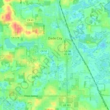
Name: Dade City topographic map, elevation, terrain.
Location: Dade City, Pasco County, Florida, United States (28.32480 -82.24117 28.38332 -82.16273)
Average elevation: 108 ft
Minimum elevation: 46 ft
Maximum elevation: 249 ft
Pasco County trails, hiking, mountain biking, running and outdoor activities
Other topographic maps
Click on a map to view its topography, its elevation and its terrain.
Wesley Chapel
United States > Florida > Pasco County
According to the United States Census Bureau, the CDP has a total area of 6.1 square miles (16 km2), of which 6.1 square miles (16 km2) is land and 0.04 square miles (0.10 km2) (0.49%) is water. The elevation is about 100 feet (30 m), combined with an inland location, creates more temperature variation in the…
Average elevation: 62 ft