
Utah Lake topographic map
Interactive map
Click on the map to display elevation.
Utah Lake
Utah Lake is a shallow freshwater lake in the center of Utah County, Utah, United States. It lies in Utah Valley, surrounded by the Provo-Orem metropolitan area. The lake's only river outlet, the Jordan River, is a tributary of the Great Salt Lake. Evaporation accounts for 42% of the lake's outflow, which leaves the lake slightly saline. The elevation of the lake is at 4,489 feet (1,368 m) above sea level. If the lake's water level rises above that, the pumps and gates on the Jordan River are left open. Recently the lake has been at a lower level because of a drought.
About this map
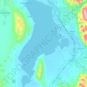
Name: Utah Lake topographic map, elevation, terrain.
Location: Utah Lake, Utah County, Utah, United States (40.00922 -111.94295 40.36121 -111.67254)
Average elevation: 4,961 ft
Minimum elevation: 4,475 ft
Maximum elevation: 10,804 ft
Utah County trails, hiking, mountain biking, running and outdoor activities
Other topographic maps
Click on a map to view its topography, its elevation and its terrain.
Saratoga Springs Park
United States > Utah > Utah County > Saratoga Springs > Saratoga Resort
Average elevation: 4,511 ft