Queens County topographic map
Interactive map
Click on the map to display elevation.
About this map
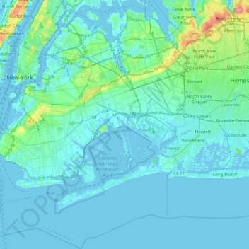
Name: Queens County topographic map, elevation, terrain.
Location: Queens County, New York, United States (40.49212 -74.04378 40.81214 -73.70023)
Average elevation: 36 ft
Minimum elevation: -26 ft
Maximum elevation: 358 ft
Many of the village street grids of Queens had only worded names, some were numbered according to local numbering schemes, and some had a mix of words and numbers. In the early 1920s, a "Philadelphia Plan" was instituted to overlay one numbered system upon the whole borough. The Topographical Bureau, Borough of Queens, worked out the details. Subway stations were only partly renamed, and some, including those along the IRT Flushing Line (7 and <7> trains), now share dual names after the original street names. In 2012, some numbered streets in the Douglaston Hill Historic District were renamed to their original names, with 43rd Avenue becoming Pine Street.
Other topographic maps
Click on a map to view its topography, its elevation and its terrain.
Brooklyn
United States > New York > New York
Brooklyn, Kings County, New York, United States
Average elevation: 30 ft
Manhattan Island
United States > New York > New York
Manhattan Island, New York, United States
Average elevation: 56 ft
Upper West Side
United States > New York > New York
Upper West Side, Manhattan Community Board 7, Manhattan, New York County, New York, United States
Average elevation: 75 ft
The Bronx
United States > New York > New York
The Bronx, New York, United States
Average elevation: 75 ft
Staten Island
United States > New York > New York
Staten Island, Richmond County, New York, United States
Average elevation: 30 ft
Mill Pond Park
United States > New York > New York
Mill Pond Park, Bronx County, The Bronx, New York, United States
Average elevation: 59 ft
Washington Heights
United States > New York > New York
Washington Heights, Manhattan Community Board 12, Manhattan, New York County, New York, United States
Average elevation: 82 ft
Freshkills Park
United States > New York > New York
Freshkills Park, Veterans Road West, Rossville, Staten Island, Richmond County, New York, 10309, United States
Average elevation: 36 ft
Starlight Park
United States > New York > New York
Starlight Park, Bronx County, The Bronx, New York, United States
Average elevation: 56 ft
New York County
United States > New York > New York
New York County, New York, United States
Average elevation: 52 ft
Fort Greene Park
United States > New York > New York
Fort Greene Park, Fort Greene, Kings County, New York, United States
Average elevation: 56 ft
Bronx Park
United States > New York > New York
Bronx Park, New York, United States
Average elevation: 98 ft
Gowanus Canal
United States > New York > New York
Gowanus Canal, Kings County, New York, United States
Average elevation: 36 ft
Kings County
United States > New York > New York
Kings County, New York, United States, Marine Park
Average elevation: 13 ft
Todt Hill
United States > New York > New York
Todt Hill, Richmond County, New York, 10304, United States
Average elevation: 164 ft
Flushing Meadows-Corona Park
United States > New York > New York
Flushing Meadows-Corona Park, New York, United States
Average elevation: 49 ft
Kissena Park
United States > New York > New York
Kissena Park, Queens County, New York, United States
Average elevation: 52 ft
Hart Island
United States > New York > New York
Hart Island, New York, United States
Average elevation: 3 ft
Coney Island Creek Park
United States > New York > New York
Coney Island Creek Park, Coney Island, Kings County, New York, United States
Average elevation: 7 ft
Jerome Park Reservoir
United States > New York > New York
Jerome Park Reservoir, The Bronx, New York, United States
Average elevation: 115 ft
Bronx County
United States > New York > New York
Bronx County, The Bronx, New York, United States
Average elevation: 69 ft
McCarren Park
United States > New York > New York
McCarren Park, Kings County, New York, United States
Average elevation: 23 ft
Prospect Park
United States > New York > New York
Prospect Park, Kings County, New York, United States
Average elevation: 112 ft
Jamaica Bay
United States > New York > New York
Jamaica Bay, Queens, New York, 11693, United States
Average elevation: 0 ft
Highland Park
United States > New York > New York
Highland Park, Queens County, New York, United States
Average elevation: 92 ft
Todt Hill
United States > New York > New York
Todt Hill, New York, 10304, United States
Average elevation: 246 ft
City Island
United States > New York > New York
City Island, The Bronx, New York, 10464, United States
Average elevation: 3 ft
Jackie Robinson Park
United States > New York > New York
Jackie Robinson Park, Brooklyn, Kings County, New York, United States
Average elevation: 72 ft
Forest Park
United States > New York > New York
Forest Park, New York, United States
Average elevation: 82 ft
Shore Road Park
United States > New York > New York
Shore Road Park, Brooklyn, New York, United States
Average elevation: 30 ft
Main Street Park
United States > New York > New York
Main Street Park, Brooklyn, Kings County, New York, United States
Average elevation: 36 ft
Kings County
United States > New York > New York
Kings County, New York, United States
Average elevation: 30 ft
Arbutus Lake
United States > New York > New York
Arbutus Lake, Staten Island, New York, United States
Average elevation: 30 ft
Middleton Playground
United States > New York > New York
Middleton Playground, Brooklyn, Kings County, New York, United States
Average elevation: 43 ft
Soundview Park
United States > New York > New York
Soundview Park, New York, United States
Average elevation: 20 ft
Richmond County
United States > New York > New York
Richmond County, New York, United States
Average elevation: 30 ft