
Make a donation
Gear up for your next adventure:
As an Amazon Associate, this site earns from qualifying purchases at no extra cost to you.
William B. Umstead State Park topographic map
Click on the map to display elevation.
Make a donation
Gear up for your next adventure:
As an Amazon Associate, this site earns from qualifying purchases at no extra cost to you.
William B. Umstead State Park
Umstead is part of the Southeastern mixed forests ecoregion. The topography is hilly, and it has several artificial lakes (which are very common in Wake County, partially due to a flood control plan implemented over the last half-century).
Make a donation
Gear up for your next adventure:
As an Amazon Associate, this site earns from qualifying purchases at no extra cost to you.
About this map
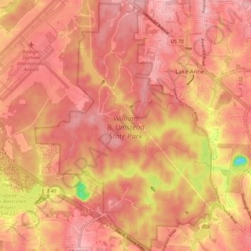
Name: William B. Umstead State Park topographic map, elevation, terrain.
Average elevation: 381 ft
Minimum elevation: 13 ft
Maximum elevation: 509 ft
Wake County trails, hiking, mountain biking, running and outdoor activities
Make a donation
Gear up for your next adventure:
As an Amazon Associate, this site earns from qualifying purchases at no extra cost to you.
Other topographic maps
Click on a map to view its topography, its elevation and its terrain.
Lake Johnson
United States > North Carolina > Wake County > Raleigh > Orchards
Average elevation: 397 ft
Lake Raleigh
United States > North Carolina > Wake County > Raleigh > Isle Forest
Average elevation: 341 ft
Make a donation
Gear up for your next adventure:
As an Amazon Associate, this site earns from qualifying purchases at no extra cost to you.