
Island of Montreal topographic map
Interactive map
Click on the map to display elevation.
Island of Montreal
The topography of the island has been significantly altered by human activity, as evidenced by historical maps that name a lake St. Pierre in the island. This lake, and several other watercourses, have been drained or covered over as the city developed, while areas on the island's shores have been reclaimed and extended. The southwest of the island is separated by the Lachine Canal between Lachine and Montreal's Old Port; this portion of the island is partially divided further by the Canal de l'Aqueduc, running roughly parallel to the Lachine Canal, beginning in the borough of LaSalle and continuing between the boroughs of Le Sud-Ouest and Verdun.
About this map
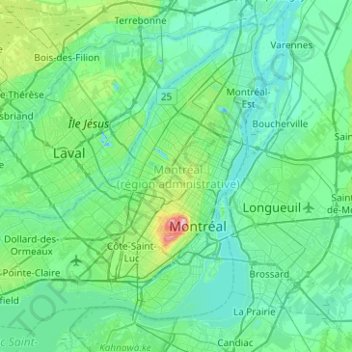
Name: Island of Montreal topographic map, elevation, terrain.
Average elevation: 98 ft
Minimum elevation: -30 ft
Maximum elevation: 751 ft
Other topographic maps
Click on a map to view its topography, its elevation and its terrain.
Mount Royal
Canada > Quebec > Urban agglomeration of Montreal > Montreal
The hill is part of the Monteregian Hills situated between the Laurentians and the Appalachian Mountains. It gave its Latin name, Mons Regius, to the Monteregian chain. The hill consists of three peaks: Colline de la Croix (or Mont Royal proper) at 233 m (764 ft), Colline d'Outremont (or Mount Murray, in the…
Average elevation: 364 ft
Saint Helen's Island
Canada > Quebec > Urban agglomeration of Montreal > Montreal
Average elevation: 49 ft
Parc Léon-Provancher
Canada > Quebec > Urban agglomeration of Montreal > Montreal
Average elevation: 174 ft
Colline de l'Abri
Canada > Quebec > Urban agglomeration of Montreal > Montreal
Average elevation: 394 ft
Mount Royal Park
Canada > Quebec > Urban agglomeration of Montreal > Montreal
The mountain is part of the Monteregian Hills situated between the Laurentians and the Appalachian Mountains. It gave its Latin name, Mons Regius, to the Monteregian chain. The mountain consists of three peaks: Colline de la Croix (or Mont Royal proper) at 233 m (764 ft), Colline d'Outremont (or Mount Murray,…
Average elevation: 361 ft
Banc de Châteauguay
Canada > Quebec > Urban agglomeration of Montreal > Dorval
Average elevation: 66 ft
Westmount Park
Canada > Quebec > Urban agglomeration of Montreal > Westmount
Average elevation: 217 ft
Mount Royal
Canada > Quebec > Urban agglomeration of Montreal > Montreal
The hill is part of the Monteregian Hills situated between the Laurentians and the Appalachian Mountains. It gave its Latin name, Mons Regius, to the Monteregian chain. The hill consists of three peaks: Colline de la Croix (or Mont Royal proper) at 233 m (764 ft), Colline d'Outremont (or Mount Murray, in the…
Average elevation: 364 ft
Parc-nature du Bois-de-Liesse
Canada > Quebec > Urban agglomeration of Montreal > Montreal
Average elevation: 92 ft
Terra Cotta
Canada > Quebec > Urban agglomeration of Montreal > Pointe-Claire
Average elevation: 118 ft