
Kings County topographic map
Interactive map
Click on the map to display elevation.
About this map
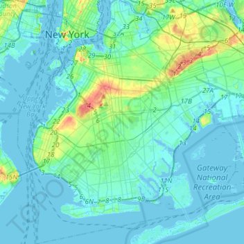
Name: Kings County topographic map, elevation, terrain.
Location: Kings County, New York, United States (40.55034 -74.05669 40.73943 -73.83295)
Average elevation: 30 ft
Minimum elevation: -33 ft
Maximum elevation: 203 ft
New York trails, hiking, mountain biking, running and outdoor activities
Other topographic maps
Click on a map to view its topography, its elevation and its terrain.
Freshkills Park
United States > New York > New York
The initial plan was to raise the elevation of the land by filling for three years and then to redevelop it as a multi-use area with residential, recreational, and industrial components. However, three years turned into fifty years. New York City's population was growing and generating more trash and it was…
Average elevation: 36 ft
Flushing Meadows-Corona Park
United States > New York > New York
Around 1907, contractor Michael Degnon, whose firm constructed the Williamsburg Bridge, the Cape Cod Canal, and the Steinway subway tunnel (used by today's 7 and <7> trains), purchased large tracts of marsh near Flushing Creek. At the time, the land was considered "all but worthless". Degnon envisioned…
Average elevation: 49 ft
Kissena Park
United States > New York > New York
Kissena Park's natural features were formed during the Wisconsin glaciation, about 20,000 years ago. The site of Flushing Meadows–Corona Park, slightly west of Kissena Park, was originally part of the ancestral path of the Hudson River, and the present-day Kissena Lake was located on the eastern shore of the…
Average elevation: 52 ft