
Panguitch Lake topographic map
Interactive map
Click on the map to display elevation.
About this map
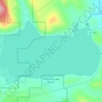
Name: Panguitch Lake topographic map, elevation, terrain.
Location: Panguitch Lake, Garfield County, Utah, United States (37.70752 -112.66119 37.72596 -112.62316)
Average elevation: 8,294 ft
Minimum elevation: 8,123 ft
Maximum elevation: 8,881 ft
Garfield County trails, hiking, mountain biking, running and outdoor activities
Other topographic maps
Click on a map to view its topography, its elevation and its terrain.
Bryce Canyon City
United States > Utah > Garfield County > Bryce Canyon City
Average elevation: 7,667 ft
Panguitch
United States > Utah > Garfield County
Panguitch has a cool semi-arid climate (Köppen BSk) with summers featuring hot afternoons and cold mornings, and cold, dry winters. The high altitude and relatively high latitude means that mornings are cold throughout the year and freezing for most of it: between 1971 and 2000 an average of 227.7 mornings…
Average elevation: 6,703 ft
Panguitch
United States > Utah > Garfield County > Panguitch
Panguitch was first settled in March 1864, when Jens Nielsen, a Danish convert to The Church of Jesus Christ of Latter-day Saints, led a group of 54 families eastward from Parowan and Beaver to the Sevier River. Due to the area's high elevation, 6,600 feet (2,000 m) above sea level, winter's cold weather…
Average elevation: 6,827 ft