
Semarang topographic map
Interactive map
Click on the map to display elevation.
Semarang
Semarang is located on the northern coast of Java. The city of Semarang is one of the important cities located on the north coast of Java and as the main hub connecting Jakarta and Surabaya, and cities in the southern interior of Java Surakarta and Yogyakarta. Semarang City has a height ranging from 2 m (6.6 ft) below sea level up to 340 m (1,120 ft) above sea level with a slope of 0%–45%. Semarang City is a city that has a unique topographic condition in the form of a narrow lowland area and hilly areas extending from the west side to the east side of Semarang City. The city is located about 558 km (347 mi) east of Jakarta and 312 km (194 mi) west of Surabaya.
About this map
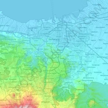
Name: Semarang topographic map, elevation, terrain.
Location: Semarang, Central Java, Java, Indonesia (-7.11446 110.26729 -6.92819 110.50888)
Average elevation: 351 ft
Minimum elevation: -3 ft
Maximum elevation: 2,582 ft
Other topographic maps
Click on a map to view its topography, its elevation and its terrain.
Green Ambarawa Residence
Indonesia > Central Java > Kabupaten Semarang > Banyubiru
Average elevation: 1,549 ft
Gantangan Burung Bung Karno Dukuh Salatiga
Indonesia > Central Java > Salatiga > Dukuh > Glogolan
Average elevation: 1,965 ft
Perumahan Griya Mustika Jati
Indonesia > Central Java > Kabupaten Semarang > Ambarawa
Average elevation: 1,745 ft
kandangserang Selatan
Indonesia > Central Java > Pekalongan > Kandangserang
Average elevation: 1,335 ft
Menara Pandang Teratai Purwokerto
Indonesia > Central Java > Banyumas > Purwokerto
Average elevation: 240 ft