
Duluth topographic map
Interactive map
Click on the map to display elevation.
About this map
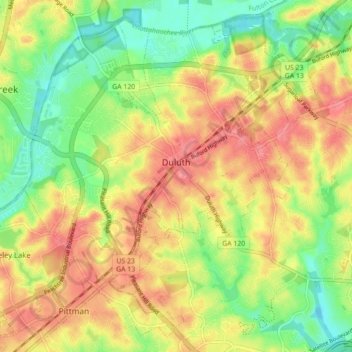
Name: Duluth topographic map, elevation, terrain.
Location: Duluth, Gwinnett County, Georgia, United States (33.96670 -84.18216 34.03323 -84.09429)
Average elevation: 1,001 ft
Minimum elevation: 873 ft
Maximum elevation: 1,115 ft
Gwinnett County trails, hiking, mountain biking, running and outdoor activities
Other topographic maps
Click on a map to view its topography, its elevation and its terrain.
Pine Ridge Country Club Estates
United States > Georgia > Gwinnett County > Lawrenceville
Average elevation: 1,060 ft