
Make a donation
Gear up for your next adventure:
As an Amazon Associate, this site earns from qualifying purchases at no extra cost to you.
Sweet Water Park topographic map
Click on the map to display elevation.
Make a donation
Gear up for your next adventure:
As an Amazon Associate, this site earns from qualifying purchases at no extra cost to you.
About this map
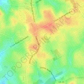
Name: Sweet Water Park topographic map, elevation, terrain.
Average elevation: 958 ft
Minimum elevation: 873 ft
Maximum elevation: 1,024 ft
Make a donation
Gear up for your next adventure:
As an Amazon Associate, this site earns from qualifying purchases at no extra cost to you.
Other topographic maps
Click on a map to view its topography, its elevation and its terrain.
Make a donation
Gear up for your next adventure:
As an Amazon Associate, this site earns from qualifying purchases at no extra cost to you.
Buford
United States > Georgia > Gwinnett County
Buford is located in both northern Gwinnett County in northern Georgia, with a small portion extending north into Hall County. The city is a suburb within the Atlanta metropolitan area. According to the United States Census Bureau, as of 2010 the city has a total land area of 17.09 square miles (44.26 km2), of…
Average elevation: 1,115 ft
Make a donation
Gear up for your next adventure:
As an Amazon Associate, this site earns from qualifying purchases at no extra cost to you.
Sugar Hill
United States > Georgia > Gwinnett County
According to the United States Census Bureau, as of 2010 the city of Sugar Hill had a total land area of 10.6 square miles (27.5 km2), of which 0.04 square miles (0.1 km2), or 0.33%, was water. The U.S. Geological Survey lists the city's elevation as 1,149 feet (350 m).
Average elevation: 1,089 ft
Snellville
United States > Georgia > Gwinnett County
Compared to most large cities around the world at approximately the same latitude (33°39'), such as Beirut, Casablanca, Dallas, Los Angeles, and Phoenix, Snellville has lower average winter temperatures. The primary reason for this is that the North American continent extends into high latitudes that allows…
Average elevation: 984 ft
Make a donation
Gear up for your next adventure:
As an Amazon Associate, this site earns from qualifying purchases at no extra cost to you.
Buford
United States > Georgia > Gwinnett County
Buford is located in both northern Gwinnett County in northern Georgia, with a small portion extending north into Hall County. The city is a suburb within the Atlanta metropolitan area. According to the United States Census Bureau, as of 2010 the city has a total land area of 17.09 square miles (44.26 km2), of…
Average elevation: 1,115 ft
Make a donation
Gear up for your next adventure:
As an Amazon Associate, this site earns from qualifying purchases at no extra cost to you.
Pine Ridge Country Club Estates
United States > Georgia > Gwinnett County > Lawrenceville
Average elevation: 1,060 ft
Make a donation
Gear up for your next adventure:
As an Amazon Associate, this site earns from qualifying purchases at no extra cost to you.
Sugar Hill
United States > Georgia > Gwinnett County
According to the United States Census Bureau, as of 2010 the city of Sugar Hill had a total land area of 10.6 square miles (27.5 km2), of which 0.04 square miles (0.1 km2), or 0.33%, was water. The U.S. Geological Survey lists the city's elevation as 1,149 feet (350 m).
Average elevation: 1,089 ft
Buford
United States > Georgia > Gwinnett County
Buford is located in both northern Gwinnett County in northern Georgia, with a small portion extending north into Hall County. The city is a suburb within the Atlanta metropolitan area. According to the United States Census Bureau, as of 2010 the city has a total land area of 17.09 square miles (44.26 km2), of…
Average elevation: 1,115 ft
Make a donation
Gear up for your next adventure:
As an Amazon Associate, this site earns from qualifying purchases at no extra cost to you.
Make a donation
Gear up for your next adventure:
As an Amazon Associate, this site earns from qualifying purchases at no extra cost to you.
Sugar Hill
United States > Georgia > Gwinnett County
According to the United States Census Bureau, as of 2010 the city of Sugar Hill had a total land area of 10.6 square miles (27.5 km2), of which 0.04 square miles (0.1 km2), or 0.33%, was water. The U.S. Geological Survey lists the city's elevation as 1,149 feet (350 m).
Average elevation: 1,089 ft
Make a donation
Gear up for your next adventure:
As an Amazon Associate, this site earns from qualifying purchases at no extra cost to you.