
South Burnett Regional topographic map
Interactive map
Click on the map to display elevation.
About this map
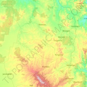
Name: South Burnett Regional topographic map, elevation, terrain.
Location: South Burnett Regional, Queensland, Australia (-26.94792 151.01326 -25.85406 152.19009)
Average elevation: 1,276 ft
Minimum elevation: 387 ft
Maximum elevation: 3,684 ft
Other topographic maps
Click on a map to view its topography, its elevation and its terrain.
Torres Strait
Several clusters of islands lie in the Strait, collectively called the Torres Strait Islands. There are at least 274 of these islands, of which 17 have present-day permanent settlements. These islands have a variety of topographies, ecosystems and formation history. Several of those closest to the New Guinea…
Average elevation: 0 ft
Kurrali Park Homestead
Australia > Queensland > Moranbah > Kurrali Park Homestead
Average elevation: 755 ft