
Santa Isabel topographic map
Interactive map
Click on the map to display elevation.
Santa Isabel
Santa Isabel (Portuguese pronunciation: [ˈsɐ̃tɐ jzɐˈbɛw]) is a municipality in the state of São Paulo in Brazil. It is part of the Metropolitan Region of São Paulo. The population is 57,966 (2020 est.) in an area of 363.33 km². The elevation is 655 m. It is located 60 miles east of the downtown of the city of São Paulo.
About this map
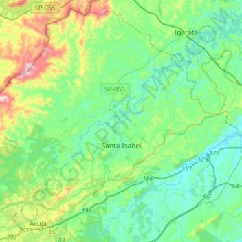
Name: Santa Isabel topographic map, elevation, terrain.
Average elevation: 2,395 ft
Minimum elevation: 1,886 ft
Maximum elevation: 4,042 ft
Other topographic maps
Click on a map to view its topography, its elevation and its terrain.
São Paulo
Brazil > São Paulo > Região Metropolitana de São Paulo
The city is on a plateau placed beyond the Serra do Mar (Portuguese for "Sea Range" or "Coastal Range"), itself a component of the vast region known as the Brazilian Highlands, with an average elevation of around 799 meters (2,621 ft) above sea level, although being at a distance of only about 70 kilometers…
Average elevation: 2,349 ft
District of Jardim Presidente Dutra
Brazil > São Paulo > Região Metropolitana de São Paulo > Guarulhos
Average elevation: 2,533 ft
Santana de Parnaíba
Brazil > São Paulo > Região Metropolitana de São Paulo
Average elevation: 2,598 ft
Embu-Guaçu
Brazil > São Paulo > Região Metropolitana de São Paulo
Embu-Guaçu is a municipality in the state of São Paulo in Brazil. It is part of the Metropolitan Region of São Paulo. The population is 69,901 (2020 est.) in an area of 155.64 km2. The elevation is 408 m.
Average elevation: 2,589 ft
São Paulo
Brazil > São Paulo > Região Metropolitana de São Paulo
The city is on a plateau placed beyond the Serra do Mar (Portuguese for "Sea Range" or "Coastal Range"), itself a component of the vast region known as the Brazilian Highlands, with an average elevation of around 799 meters (2,621 ft) above sea level, although being at a distance of only about 70 kilometers…
Average elevation: 2,575 ft
Mauá
Brazil > São Paulo > Região Metropolitana de São Paulo
The city has a special characteristic hydrographic: not be crossed by any water course from another city, since, due to the high altitude, all streams that cross the territory of Mauá has their sources inside the city limits.
Average elevation: 2,641 ft
Butantã
Brazil > São Paulo > Região Metropolitana de São Paulo > São Paulo
Average elevation: 2,451 ft
Morumbi
Brazil > São Paulo > Região Metropolitana de São Paulo > São Paulo
Average elevation: 2,497 ft
Ribeirão Pires
Brazil > São Paulo > Região Metropolitana de São Paulo
Ribeirão Pires (Pires Stream) is a city in the Metropolitan Region of the city of São Paulo, in the state of São Paulo, Brazil. It is part of the "ABC Region." The population is 124,159 (2020 est.) in an area of 99.1 km2. The elevation is 763 m.
Average elevation: 2,621 ft
São Bernardo do Campo
Brazil > São Paulo > Região Metropolitana de São Paulo > São Bernardo do Campo
Average elevation: 2,493 ft
Cotia
Brazil > São Paulo > Região Metropolitana de São Paulo
Cotia is a municipality in the state of São Paulo in Brazil. It is part of the Metropolitan Region of São Paulo. The population is 253,608 (2020 est.) in an area of 323.99 km2. The city is at an elevation of 853 m. Cotia is linked with the Rodovia Raposo Tavares highway.
Average elevation: 2,818 ft
Vargem Grande Paulista
Brazil > São Paulo > Região Metropolitana de São Paulo
Average elevation: 2,953 ft
Itaquaquecetuba
Brazil > São Paulo > Região Metropolitana de São Paulo > Itaquaquecetuba
Itaquaquecetuba is a municipality in the state of São Paulo, Brazil. It is part of the Metropolitan Region of São Paulo. The population is 375,011 (2020 est.) in an area of 82.62 square kilometres (31.90 sq mi). It sits at an elevation of 790 metres (2,592 ft).
Average elevation: 2,507 ft