
Make a donation
Gear up for your next adventure:
As an Amazon Associate, this site earns from qualifying purchases at no extra cost to you.
Glen Spey topographic map
Click on the map to display elevation.
Gear up for your next adventure:
As an Amazon Associate, this site earns from qualifying purchases at no extra cost to you.
About this map
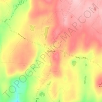
Name: Glen Spey topographic map, elevation, terrain.
Average elevation: 1,276 ft
Minimum elevation: 899 ft
Maximum elevation: 1,480 ft
Sullivan County trails, hiking, mountain biking, running and outdoor activities
Make a donation
Gear up for your next adventure:
As an Amazon Associate, this site earns from qualifying purchases at no extra cost to you.
Other topographic maps
Click on a map to view its topography, its elevation and its terrain.
Make a donation
Gear up for your next adventure:
As an Amazon Associate, this site earns from qualifying purchases at no extra cost to you.
South Fallsburg
United States > New York > Sullivan County > South Fallsburg
Average elevation: 1,329 ft
Kauneonga Lake
United States > New York > Sullivan County > Town of Bethel
Average elevation: 1,335 ft
Make a donation
Gear up for your next adventure:
As an Amazon Associate, this site earns from qualifying purchases at no extra cost to you.
Livingston Manor
United States > New York > Sullivan County > Livingston Manor
Average elevation: 1,680 ft
Grahamsville
United States > New York > Sullivan County > Town of Neversink
Grahamsville is located at latitude 41.848 and longitude -74.548. The elevation is 968 feet. Grahamsville is in the Eastern Time Zone.
Average elevation: 1,302 ft
Make a donation
Gear up for your next adventure:
As an Amazon Associate, this site earns from qualifying purchases at no extra cost to you.
Village of Wurtsboro
United States > New York > Sullivan County
Wurtsboro is in the Eastern Time Zone. Its elevation is 577 feet.
Average elevation: 669 ft
Make a donation
Gear up for your next adventure:
As an Amazon Associate, this site earns from qualifying purchases at no extra cost to you.
Mongaup Valley
United States > New York > Sullivan County > Town of Bethel
Average elevation: 1,247 ft
Woodbourne
United States > New York > Sullivan County > Town of Fallsburg > Woodbourne
Average elevation: 1,293 ft
Mongaup Valley
United States > New York > Sullivan County > Town of Bethel
Average elevation: 1,247 ft
Mountain Dale
United States > New York > Sullivan County > Town of Fallsburg
Mountaindale is a hamlet (and census-designated place) in the town of Fallsburg in Sullivan County, New York, United States, situated at an altitude of 1,010 feet (310 m).
Average elevation: 1,191 ft
Make a donation
Gear up for your next adventure:
As an Amazon Associate, this site earns from qualifying purchases at no extra cost to you.
Livingston Manor
United States > New York > Sullivan County > Livingston Manor
Average elevation: 1,690 ft
Make a donation
Gear up for your next adventure:
As an Amazon Associate, this site earns from qualifying purchases at no extra cost to you.
Grahamsville
United States > New York > Sullivan County > Town of Neversink
Grahamsville is located at latitude 41.848 and longitude -74.548. The elevation is 968 feet. Grahamsville is in the Eastern Time Zone.
Average elevation: 1,302 ft
Town of Lumberland
United States > New York > Sullivan County
Lumberland is located within the Upper Delaware Scenic and Recreational River. Elevations range from approximately 600 feet near the Delaware River to over 1,300 feet above sea level on the bluffs overlooking the Delaware, and where the Catskill Mountains begin to rise in the northern reaches of the town. The…
Average elevation: 1,181 ft
Make a donation
Gear up for your next adventure:
As an Amazon Associate, this site earns from qualifying purchases at no extra cost to you.
Make a donation
Gear up for your next adventure:
As an Amazon Associate, this site earns from qualifying purchases at no extra cost to you.