
Thank you for supporting this site ❤️
Make a donation
Make a donation
Gear up for your next adventure:
As an Amazon Associate, this site earns from qualifying purchases at no extra cost to you.
Đà Lạt topographic map
Click on the map to display elevation.
Thank you for supporting this site ❤️
Make a donation
Make a donation
Gear up for your next adventure:
As an Amazon Associate, this site earns from qualifying purchases at no extra cost to you.
About this map
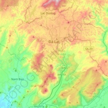
Name: Đà Lạt topographic map, elevation, terrain.
Location: Đà Lạt, Lâm Đồng Province, Vietnam (11.80798 108.31521 12.00855 108.59461)
Average elevation: 4,337 ft
Minimum elevation: 2,733 ft
Maximum elevation: 6,814 ft
Thank you for supporting this site ❤️
Make a donation
Make a donation
Gear up for your next adventure:
As an Amazon Associate, this site earns from qualifying purchases at no extra cost to you.
Other topographic maps
Click on a map to view its topography, its elevation and its terrain.
Mont Lang Biang belvédère
Vietnam > Lâm Đồng Province > Lạc Dương District > Lạc Dương
Average elevation: 5,315 ft