
Đà Lạt topographic map
Interactive map
Click on the map to display elevation.
About this map
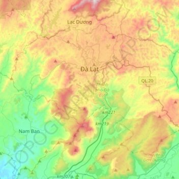
Name: Đà Lạt topographic map, elevation, terrain.
Location: Đà Lạt, Lâm Đồng Province, Vietnam (11.80798 108.31521 12.00855 108.59461)
Average elevation: 4,337 ft
Minimum elevation: 2,733 ft
Maximum elevation: 6,814 ft
Other topographic maps
Click on a map to view its topography, its elevation and its terrain.
Mont Lang Biang belvédère
Vietnam > Lâm Đồng Province > Lạc Dương District > Lạc Dương
Average elevation: 5,315 ft