
Spring Valley topographic map
Interactive map
Click on the map to display elevation.
Spring Valley
In 1936 state highway maps indicated a cemetery and a church. Initially the settlement consisted of one and one-half square miles.Spring Valley, once known as Lusk, is at the intersection of Farm roads 2416 and 2113, fourteen miles southwest of Waco in southwestern McLennan County. A post office, called Lusk after an early settler, opened in May 1890 with Tilman H. Knight as postmaster; it closed in January 1891. The community then took the name of the nearby school, which had been called Leroy when it was established in 1878. However, when the Leroy community was founded in northeastern McLennan County in 1903, the school district name was changed to Spring Valley. In the 1940s the community reported fifty residents and had a church, two businesses, and several scattered houses. Only a few houses were shown at the site on a 1975 topographic map of the area. By 2000 the population had grown to 400.
About this map
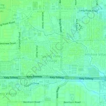
Name: Spring Valley topographic map, elevation, terrain.
Location: Spring Valley, Harris County, Texas, United States (29.78338 -95.52027 29.79882 -95.48639)
Average elevation: 82 ft
Minimum elevation: 66 ft
Maximum elevation: 95 ft
Harris County trails, hiking, mountain biking, running and outdoor activities
Other topographic maps
Click on a map to view its topography, its elevation and its terrain.
original boundary of City of Houston
United States > Texas > Harris County > Houston
Average elevation: 52 ft
Tomball
United States > Texas > Harris County > Tomball > Tomball
Settlement began in the Tomball area in the early 19th century, where settlers found an open, fertile land that received adequate rainfall—perfect conditions for farming and raising cattle. It was on a land granted in 1838 to William Hurd's heirs. In 1906 the area began to boom. Railroad line engineers often…
Average elevation: 174 ft
Mount Houston
United States > Texas > Harris County > Houston > Mount Houston
Average elevation: 69 ft
Galena Park
United States > Texas > Harris County > Galena Park > Galena Park
Average elevation: 30 ft
Hunters Ridge
United States > Texas > Harris County > Houston > Hunters Ridge
Average elevation: 82 ft
Lamar Terrace
United States > Texas > Harris County > Houston > Lamar Terrace
Average elevation: 69 ft