
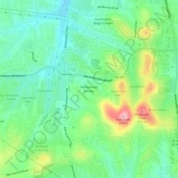
Myrtlewood Estates topographic map
Interactive map
Click on the map to display elevation.
About this map
Name: Myrtlewood Estates topographic map, elevation, terrain.
Average elevation: 676 ft
Minimum elevation: 515 ft
Maximum elevation: 1,020 ft
Davidson County trails, hiking, mountain biking, running and outdoor activities
Other topographic maps
Click on a map to view its topography, its elevation and its terrain.
Sevier Park
United States > Tennessee > Davidson County > Nashville-Davidson
Average elevation: 568 ft
Lockeland Springs Park
United States > Tennessee > Davidson County > Nashville-Davidson
Average elevation: 489 ft
Radnor Lake State Natural Area
United States > Tennessee > Davidson County > Nashville-Davidson
Average elevation: 869 ft
Antioch Park
United States > Tennessee > Davidson County > Nashville-Davidson > Antioch
Average elevation: 568 ft
Hermitage Island
United States > Tennessee > Davidson County > Nashville-Davidson
Average elevation: 515 ft
Rock Island
United States > Tennessee > Davidson County > Nashville-Davidson
Average elevation: 505 ft
Lake Wautaga
United States > Tennessee > Davidson County > Nashville-Davidson
Average elevation: 551 ft
Whites Creek
United States > Tennessee > Davidson County > Nashville-Davidson
Average elevation: 469 ft
Harpeth River
United States > Tennessee > Davidson County > Nashville-Davidson
Average elevation: 646 ft